Nationwide drone photography services give an organization with many sites one provider that captures every property or project to the same standard, on dates you choose, and delivers the results to one place. Done well, a portfolio manager can open any site, pick any date and compare it with the last visit. Done badly, you get a different vendor in every city, a different file format from each, and photos nobody can line up.
This guide is for developers, REITs, multi-site general contractors and property portfolio teams. It covers what a multi-site drone program really involves, which capture settings must stay the same across sites, the federal rules every pilot flies under, and what to check before you hire drone pilot services across many locations.
TL;DR
- A multi-site drone program is mostly a consistency problem: the same deliverables, the same capture settings and the same naming at every site, so dates can be compared.
- Altitude, image overlap and lighting drive how comparable two captures are, so they belong in a written capture standard, not in each pilot's head.
- Every commercial drone pilot in the US flies under FAA Part 107, which requires a remote pilot certificate and sets limits on altitude, visibility and airspace.
- When you hire drone pilot services across many sites, check certificates, insurance, photo ownership, privacy practice and how the data is delivered before you check the price.
- National Drone Services schedules network pilots, flies your sites on the dates you pick and delivers every capture to one shareable portal.
Table of Contents
- What nationwide drone photography services are (and are not)
- Who uses multi-site drone photography
- Consistency across sites: the part that decides the result
- The rules every pilot flies under
- What should you look for when hiring drone pilot services across many sites?
- How to set up a recurring capture program, step by step
- One place to see every site and every date
- Privacy and neighbors across many locations
- Our perspective: one standard beats fifty vendors
- How National Drone Services handles multi-site programs
- FAQ
- Sources
What nationwide drone photography services are (and are not)
A national drone company takes on the whole job for a list of sites: it finds a qualified pilot near each one, sets the capture standard, schedules the flights and returns the results in one format. You deal with one team instead of one vendor per city.
It is not the same as a single listing shoot. A one-off photo set for one building can come from any good local photographer. The value of a nationwide program shows up on the second, fifth and tenth visit, when every capture can be laid next to the last one.
There are three common ways organizations buy drone photography across many sites. Each has a fair use.
| Approach | Works well when | What to watch |
|---|---|---|
| Local vendor per site | You have a few sites and staff to manage each vendor | Formats, angles and naming drift from vendor to vendor |
| Pilot marketplace | You want to post jobs and pick pilots yourself | Your team sets the standard and checks every delivery |
| One managed provider | You want one contact, one standard and one delivery point | Confirm coverage for each location before you commit |
The takeaway: the more sites and repeat visits you have, the more the management work matters compared with the flying.
Who uses multi-site drone photography
The buyers differ, but they want the same thing: a dated, comparable record of many places they cannot visit every week.
- Developers. Land, entitlement and construction phases run at the same time in different markets. A top-down view of each site on set dates keeps investors and lenders on the same page.
- REITs and asset managers. A portfolio-wide set of aerial photos gives a current view of roofs, parking and grounds for planning and reporting. See our drone services for property management for the property side.
- Multi-site general contractors. Progress photos and maps on a steady rhythm help project teams answer "where are we?" without a site visit. Our turnkey aerial data for construction page covers the deliverables.
- Property portfolios and leasing teams. Marketing angles and site overview photos keep listings current. The real estate drone photography page shows the listing side.
Research points to where the value gets lost. A literature review of drone-based construction progress monitoring found a gap in studies that integrate visual monitoring with construction management systems. In plain terms, imagery helps most when it lands where the team already works, not in a separate folder.
The lesson: buy the record, not the flight.
Consistency across sites: the part that decides the result
Two captures can only be compared if they were taken the same way. When a dozen pilots fly a dozen sites, each one makes small choices. Those choices add up to data that does not line up.
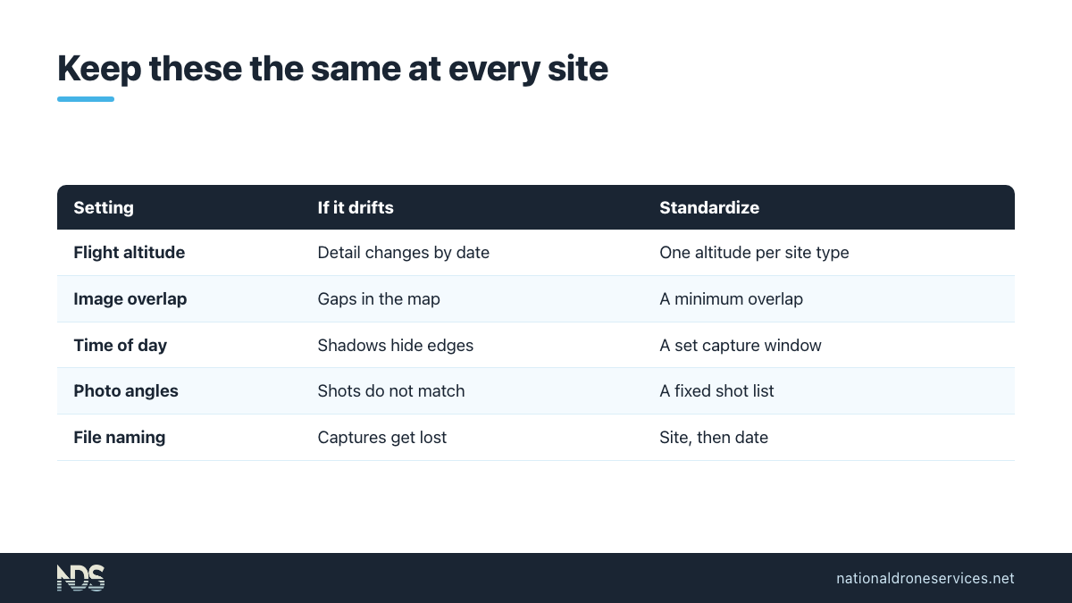
Mapping software vendors are clear about what matters. Pix4D recommends at least 75% frontal and 60% side overlap for general mapping and keeping the camera at a constant height. The same page notes that flight heights should not differ much between flights, because different heights give different detail.
That detail is measured as ground sampling distance (GSD), the distance between two consecutive pixel centers measured on the ground. Fly higher and each pixel covers more ground. DJI's guide makes the trade-off from the other side: go too low and the job takes up extra storage without always adding useful detail.
Lighting matters too. A study of drone orthomosaics found that splitting work across flights causes variations in illumination, shadows and saturated images. The same study found altitude above ground was the main factor in accuracy. That is one research setting, not a promise for every site, but the direction is clear.
| Variable | What happens if it drifts | What to standardize |
|---|---|---|
| Flight altitude | Detail changes between dates, so small changes hide | One altitude per site type, written down |
| Image overlap | Gaps or soft areas in the map | A minimum overlap for every mapping flight |
| Time of day | Shadows move and hide edges | A capture window, such as midday |
| Photo angles | Before and after shots do not match | A shot list with fixed positions per site |
| Deliverable set | One site gets a map, another gets only photos | The same defined deliverables per site type |
| File naming | Nobody can find last month's capture | Site, then date, every time |
Consistent method matters more than perfect conditions on any single day.
The rules every pilot flies under
Commercial drone work in the US falls under the FAA's Part 107 rules. You do not need to know them in depth, but you should know enough to ask good questions. Check the current rules for your operation, since they change.
- Certificate. No one may act as remote pilot in command unless they hold a remote pilot certificate with a small UAS rating.
- Staying current. Pilots must complete a knowledge qualification within the previous 24 calendar months.
- Altitude and weather. The drone cannot fly higher than 400 feet above ground level, with an allowance near structures. The same section requires 3 statute miles of visibility and set distances from clouds.
- Line of sight. The crew must be able to see the aircraft throughout the entire flight.
- Controlled airspace. Sites near many airports need prior authorization from Air Traffic Control before a flight.
- Night flights. Flying at night requires recent training and anti-collision lighting visible for 3 statute miles.
- Remote ID. Since September 2023, drones flying in US airspace must meet the remote identification requirement unless an exception applies.
What that means for you: weather, airspace and visibility can move a flight date at any one site. A good provider tells you early and reschedules, instead of flying a poor capture to hit the date.
What should you look for when hiring drone pilot services across many sites?
Price is easy to compare. The things that cause problems on a portfolio are harder to see on a quote. The National Association of Realtors gives a useful starting list for anyone hiring a drone operator: confirm the remote pilot certificate, check insurance and settle photo ownership in the contract. Multi-site buyers should go further.
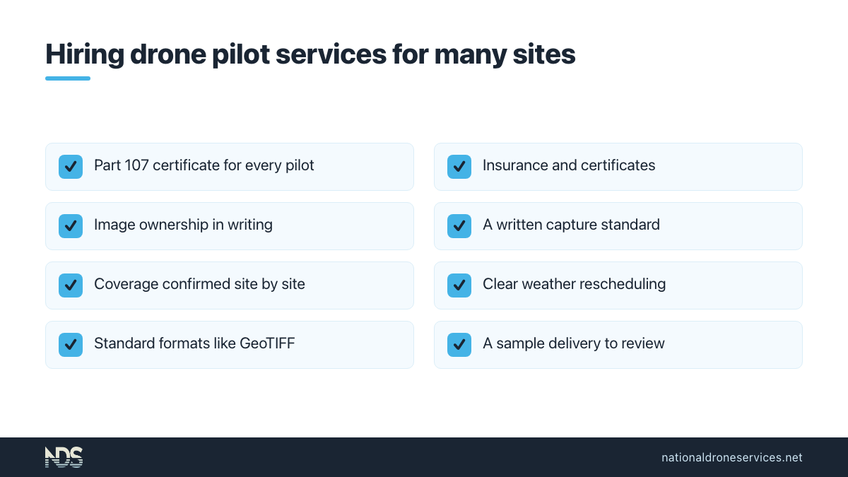
- Pilot credentials. Ask how the provider confirms every pilot holds a current Part 107 certificate, not just the pilots in one city.
- Insurance. Ask what coverage the pilots carry and how certificates of insurance are handled for your properties.
- Ownership and use of the imagery. Get it in writing who owns the photos and maps, and how long you can access them.
- A written capture standard. Ask to see the altitude, overlap, shot list and deliverables they will use at every site.
- Coverage, site by site. Send your actual site list and ask the provider to confirm each location. "Nationwide" on a website is not the same as a pilot near your site.
- Scheduling and rescheduling. Ask how dates are set, how weather delays are handled and how you will hear about them.
- Delivery format. Look for standard formats you can open elsewhere, such as GeoTIFF, which the Open Geospatial Consortium describes as a standard for using the Tagged Image File Format for georeferenced imagery.
- One place to review. Ask to see a sample delivery. If your team has to dig through email attachments, the program will stall.
- Measurement limits. Measurements from drone maps are estimates for planning and tracking change. They do not replace a licensed surveyor.
A short checklist like this filters out most mismatches before the first flight.
How to set up a recurring capture program, step by step
A recurring program is a list of sites, a standard and a calendar. Here is a simple way to build one.
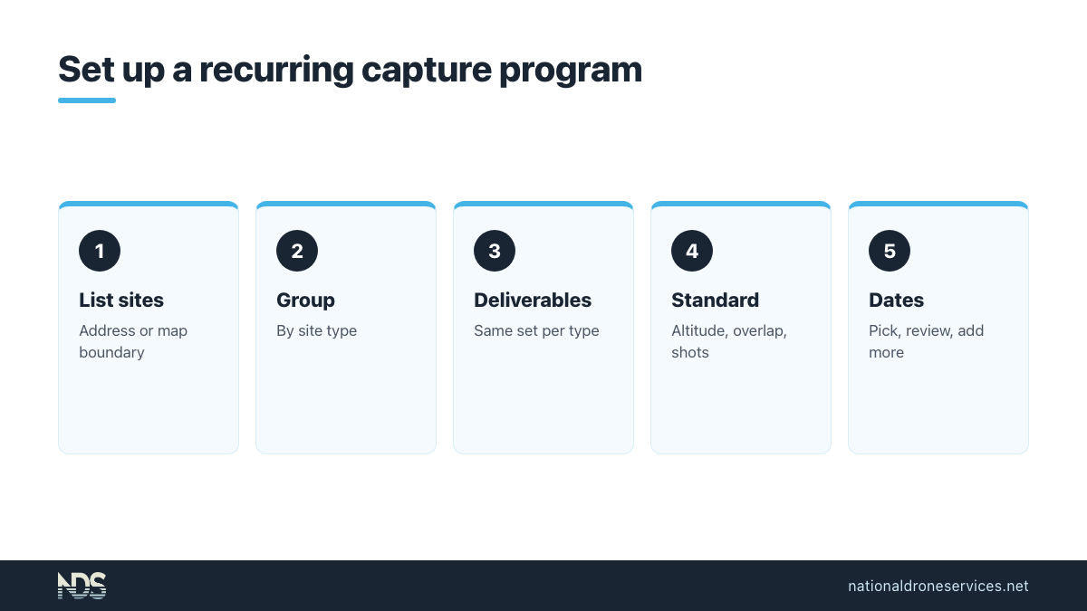
- List every site with an address or a boundary drawn on a map, plus a contact for site access.
- Group sites by type (active construction, stabilized property, land) because each type needs different deliverables.
- Pick the deliverables per type. A construction site may need a stitched map, panoramas and overview photos. A stabilized property may need overview photos and marketing angles.
- Write the capture standard using the table above: altitude, overlap, time window, shot list and naming.
- Choose capture dates. Match the rhythm to how fast each site changes. Active construction usually needs more dates than a stable asset.
- Review the first round together. Check that every site came back the same way, then lock the standard.
- Keep adding dates to the same site record so the history builds in one place.
A missing date with a note beats a silent gap in the record.
One place to see every site and every date
The delivery decides whether a multi-site program gets used. A folder of files per site per month quickly becomes hundreds of folders. People stop opening them.
A good delivery is organized the way you think about the portfolio: property or project first, then each capture by date. From there your team should be able to:
- Find a site on a map and open its latest capture.
- Switch between capture dates and compare two of them side by side.
- View the stitched map, 3D views and photos in a browser without special software.
- Measure distance, area and perimeter as estimates for planning.
- Add their own notes and annotations and build their own reports.
- Share a view-only link with an owner, lender or vendor, and turn it off later.
- Download the files when another system needs them.
Our pages on aerial data for construction and drone services for property management show what that looks like.
The history is the product. Each new date makes every earlier one more useful.
Privacy and neighbors across many locations
Flying many sites means flying near many neighbors, tenants and the public. The voluntary best practices from an NTIA-convened group of industry and privacy stakeholders are a sensible baseline. They say organizations hiring drone operators should consider these practices when setting contract terms.
In practice, that points to a few habits:
- Give tenants and site staff notice of the general date and area of a flight where practical.
- Fly the property you ordered and keep time over neighboring private property to a minimum.
- Keep imagery in a private account and share it only with people who need it.
- Have a clear contact for privacy questions at each site.
Respect at the site level protects the program at the portfolio level.
Our perspective: one standard beats fifty vendors
When organizations come to us with a list of sites, the problem is rarely finding a pilot. It is that the photos from last quarter do not match the photos from this quarter, and nobody can say where the files went. The flights happened. The record did not.
That happens because each local vendor runs their own way. Different altitudes, different shot lists, different file names and different delivery links. Each job looks fine on its own. Put twenty of them side by side and they cannot be compared.
We built National Drone Services around the record, not the flight. Each site is a property or project in your account, and each capture is saved under it by date, so the timeline builds itself. Sharing is a view-only link with no login for the person viewing, because a link that opens in a browser gets read. You can turn any link off later.
Our advice: pick one standard before you pick one vendor. Sites are flown one at a time. Portfolios are managed by comparison.
How National Drone Services handles multi-site programs
National Drone Services is a done-for-you service. You do not need a drone program or any software skills. For each site, you pick the deliverables you want, mark the property on a map, choose your capture dates and add site notes. We line up a pilot from our network, handle the flight and processing, and the results show up in your account under that property, saved by date.
Every pilot who flies for us must hold an FAA Part 107 certificate. You can add more capture dates to the same site at any time, so each visit adds to the same timeline. Deliverables come from a defined set, such as mapped aerial views, site overview photos, 360 panoramas and marketing angle shots, so the same site type gets the same package everywhere.
Coverage depends on the location. Send us your site list and our team will check each address and follow up. Start with the page that fits your portfolio: construction, property management, or the National Drone Services homepage for everything else.
FAQ
What are nationwide drone photography services?
They are drone photography and mapping programs run by one provider across many sites in different cities or states. The provider finds a qualified pilot near each site, uses one capture standard, schedules the dates and delivers everything to one place. The goal is a record you can compare across sites and over time, not one-off photos.
What should I look for when hiring drone pilot services for many sites?
Confirm every pilot holds a current FAA Part 107 certificate, ask about insurance, and settle who owns the imagery in writing. Then ask for the written capture standard, site-by-site coverage confirmation, how weather delays are handled, and a sample delivery. Those answers matter more on a portfolio than the price of a single flight.
How do you keep drone photos consistent across different sites?
Write down the settings that change the result: flight altitude, image overlap, time of day, photo angles, the deliverables per site type and how files are named. Every pilot flies to that standard. Review the first round of captures together, fix anything that drifted, and then keep the standard fixed so later dates line up.
Can a drone provider fly the same sites on a recurring schedule?
Yes. With National Drone Services you pick capture dates on a calendar when you order and can add more later. Each new date is saved under the same property, so the history builds in one place. Weather and airspace can move a date at any site, so expect occasional rescheduling.
Can drone maps replace a land survey?
No. Measurements from drone maps, such as distance, area and stockpile volume, are estimates for planning and tracking change. They do not replace a licensed surveyor and should not be used for engineering or legal decisions. For those, hire a licensed surveyor and use the drone record as supporting context.
Sources
- Literature Review on Visual Construction Progress Monitoring Using Unmanned Aerial Vehicles, IGLC
- Selecting the Image Acquisition Plan Type, Pix4D
- Ground sampling distance (GSD) in photogrammetry, Pix4D
- Ground Sample Distance, DJI Enterprise
- An Analysis of the Influence of Flight Parameters in the Generation of UAV Orthomosaicks, Sensors (PMC)
- 14 CFR 107.12, Requirement for a remote pilot certificate, Legal Information Institute
- 14 CFR 107.65, Aeronautical knowledge recency, Legal Information Institute
- 14 CFR 107.51, Operating limitations for small unmanned aircraft, Legal Information Institute
- 14 CFR 107.31, Visual line of sight aircraft operation, Legal Information Institute
- 14 CFR 107.41, Operation in certain airspace, Legal Information Institute
- 14 CFR 107.29, Operation at night, Legal Information Institute
- 14 CFR 89.105, Remote identification requirement, Legal Information Institute
- Drones, National Association of Realtors
- OGC GeoTIFF, Open Geospatial Consortium
- Voluntary Best Practices for UAS Privacy, Transparency, and Accountability, NTIA-convened stakeholders