DroneDeploy Alternative
A DroneDeploy Alternative Built for Drone Service Providers
DataDelivery™ gives independent pilots and growing drone service companies one place to process, organize, present, and professionally deliver drone data to their clients — without adopting an enterprise reality-capture system built around workflows they may not need.
Free plan — no credit card required. Upgrade only when you are ready.
Already using another drone platform? DataDelivery is designed for DSPs whose priority is turning captured data into a polished, accessible client deliverable.
Why Drone Service Providers Look for an Alternative
Most independent pilots and small teams do not need an enterprise reality-capture suite. They need to deliver great-looking projects to clients, efficiently.
Professional client delivery
A polished, client-facing portal — not a raw file-sharing folder full of filenames.
Right-sized tooling
Processing and delivery tools without an unnecessarily broad enterprise system to learn and administer.
Pricing that fits a small business
Plans that make sense for a smaller drone business — including a free plan and flat, no-per-seat tiers.
Everything in one place
Organize imagery, maps, models, reports, and repeat captures together — grouped by property, site, and date.
Clients view results easily
Clients explore deliverables in a browser with no login and no complicated software to learn.
Built for delivering to clients
A platform designed around delivering finished work to external customers — the core of a service business.
Everything You Need to Deliver Drone Projects Professionally
Purpose-built viewers and tools that make your drone data more valuable and your delivery process more efficient. Every screenshot below is the real platform.
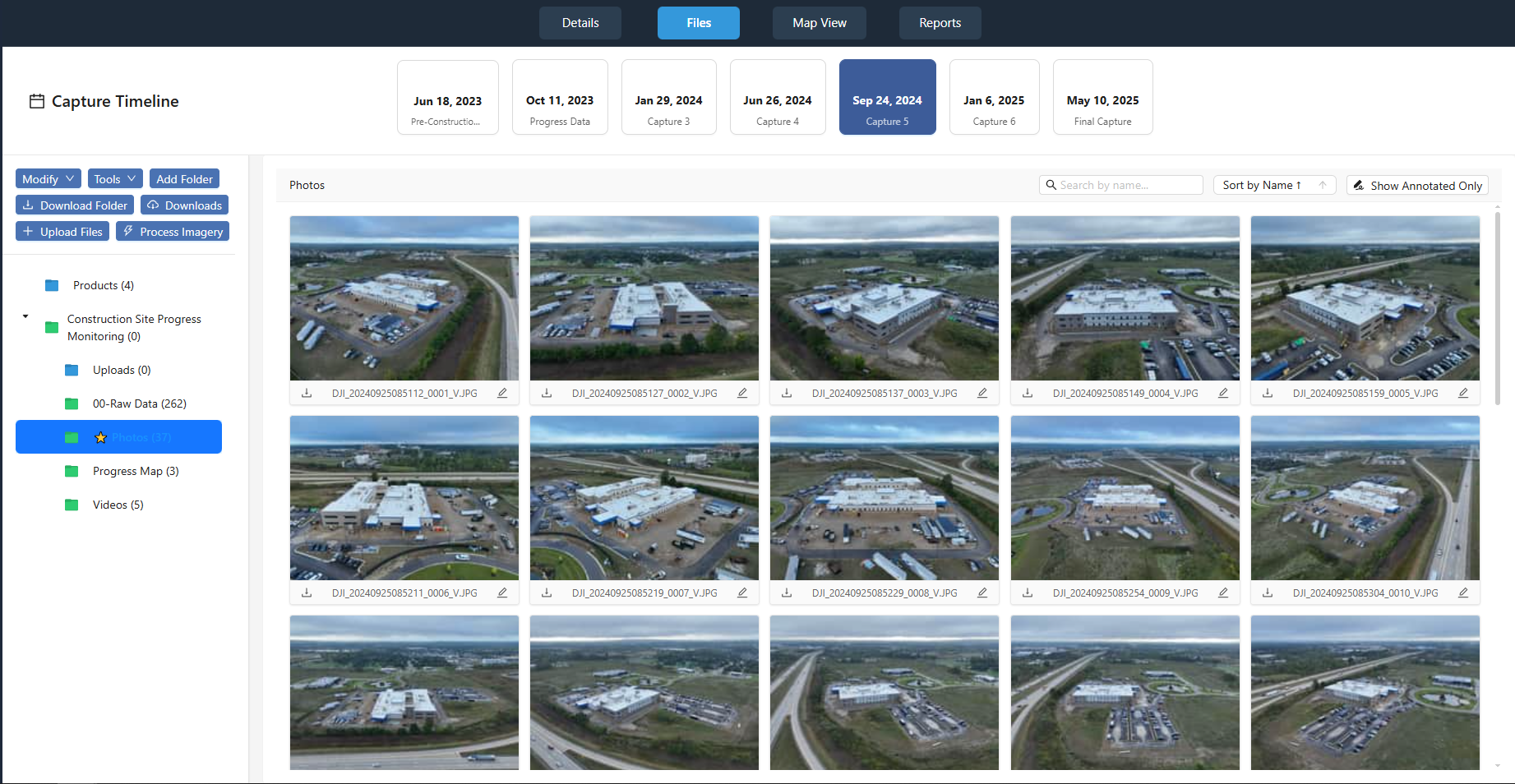
Capture-based project organization
Each job is structured into individual captures, with every flight organized by date — so jobs stay clear and manageable as they grow.
- Hosted photos, videos, and 360° panoramas
- Organized, downloadable deliverables
- Multi-capture and recurring project timelines
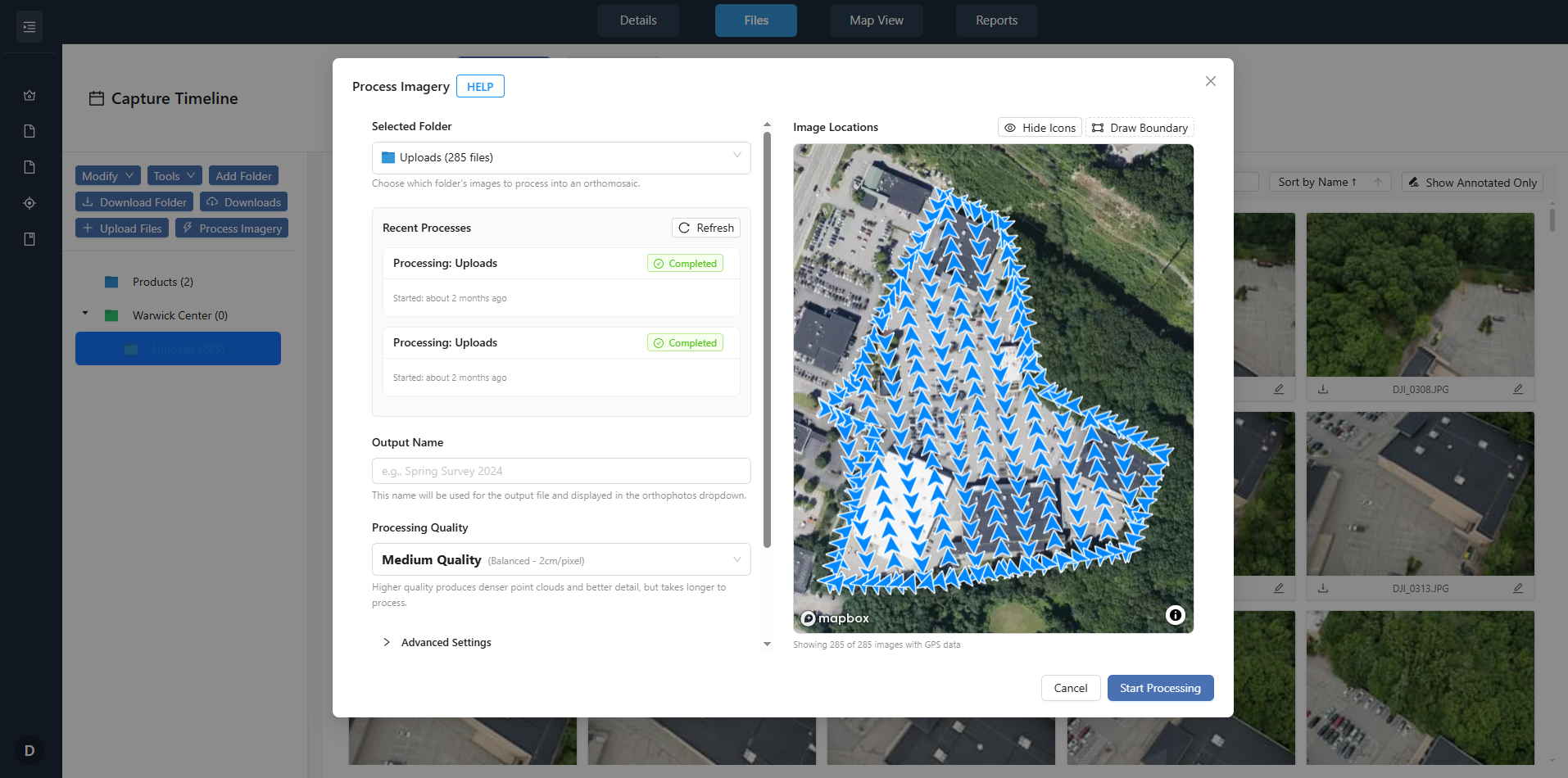
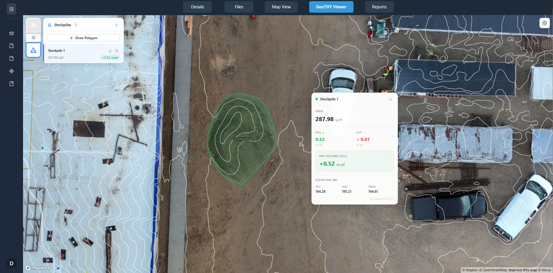
Orthomosaic & point-cloud processing
Generate georeferenced orthomosaics and 3D point clouds from your raw imagery without leaving the platform — no separate photogrammetry software required.
- 2D orthomosaics and 3D point clouds from raw photos
- Point clouds viewable directly in the browser
- Outputs land in the same job and capture structure
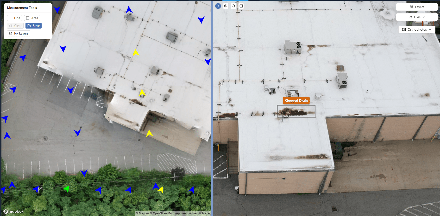
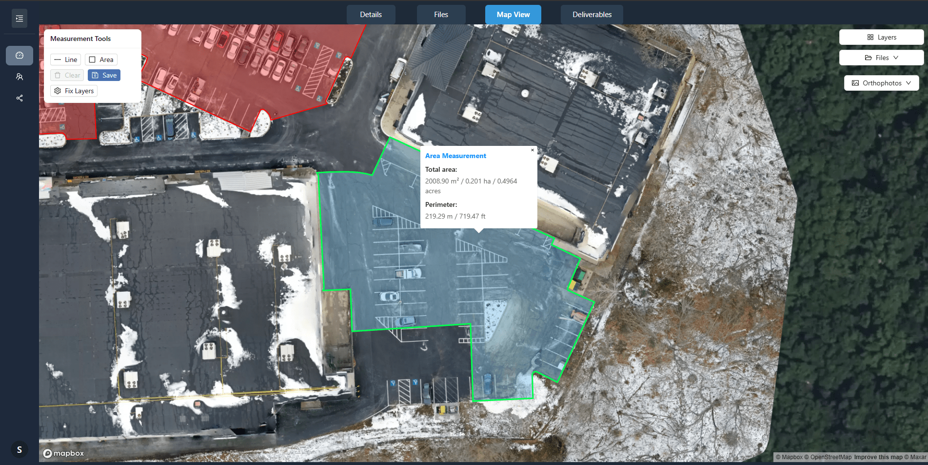
Map-based presentation & annotations
Clients view orthomosaics and site imagery on an interactive map — navigating by location, not filenames. Mark issues and add notes directly on the imagery.
- Map-based project presentation
- Measurements and annotations
- Client-ready reports built from your data
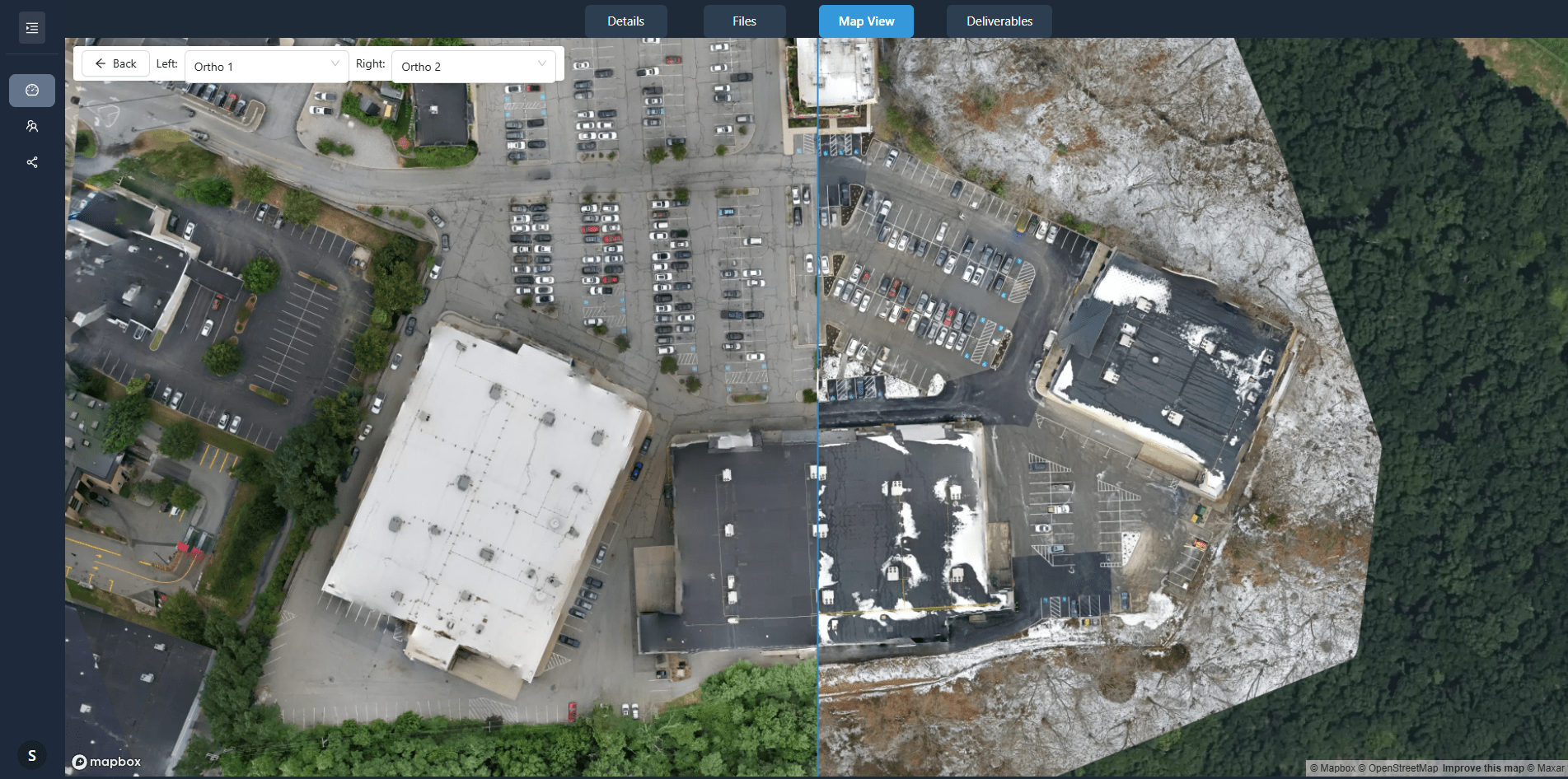
Time-based comparison for recurring work
For recurring jobs, compare any two capture dates side-by-side. Synchronized views document construction progress, site changes, or maintenance issues over time.
- Side-by-side comparison of any two dates
- Recurring-capture support, organized chronologically
- Progress documentation without downloading files
DataDelivery vs. DroneDeploy
The right platform depends on what your business is trying to accomplish. DataDelivery focuses on helping DSPs process, manage, and deliver drone projects. DroneDeploy serves a broader enterprise reality-capture market.
| Capability | DataDelivery | DroneDeploy |
|---|---|---|
| Primary audience | Independent and growing DSPs | Enterprise reality-capture teams |
| Professional client-facing delivery | Yes | Yes |
| Hosted drone imagery | Yes | Yes |
| Orthomosaic processing | Yes | Yes |
| Point-cloud support | Yes | Yes |
| Annotations and reports | Yes | Yes |
| Multiple project captures (time-series) | Yes | Yes |
| No-login client portal | Yes | Account typically required — verify with DroneDeploy |
| Ground-based 360° capture | No | Yes |
| Automated drone and dock operations | No | Yes |
| Robotics workflows | No | Yes |
| Enterprise program administration | Not the primary focus | Yes |
| Straightforward DSP-oriented plans | Free – $199.99/mo, no per-seat fees | Contact DroneDeploy for current plan details |
DroneDeploy may be the stronger fit for organizations that need aerial and ground reality capture, robotics, dock automation, or enterprise-wide administration. DataDelivery is built for DSPs that want an accessible platform for processing and professionally delivering drone projects.
DroneDeploy is a trademark of its respective owner. National Drone Services and DataDelivery are not affiliated with or endorsed by DroneDeploy. Comparison information is based on publicly available product information as of June 2026 and should be independently verified.
From Raw Capture to Client-Ready Project
Four steps, all in one platform.
-
1
Upload your project data
Drag and drop photos, videos, and panoramas into organized, capture-based folders.
-
2
Process and organize the deliverables
Generate orthomosaics and point clouds with the built-in processing pipeline.
-
3
Add context with maps, annotations & reports
Present imagery on a map, mark issues, take measurements, and build client-ready reports.
-
4
Share a polished project experience
Send a no-login portal link. Revoke anytime, or enable a watermarked preview before payment.
Pricing Built for Drone Service Providers
Start on the free plan — no credit card required. Every plan includes full platform access with no per-seat fees; higher tiers add capacity and branding.
Free
$0/mo
Always free
- 1 personal job / month (2 captures)
- 25GB storage
- 1 image processing / day
- Client sharing
Starter
$9.99/mo
or $100/yr
- 3 personal jobs / month (3 captures)
- 100GB storage
- 1 image processing / day
Basic
$29.99/mo
or $299.99/yr
- 5 personal jobs / month (5 captures)
- 500GB storage
- 3 image processing / day
- Custom branding
Premium
$79.99/mo
or $799.99/yr
- 15 personal jobs / month (10 captures)
- 1000GB storage
- 5 image processing / day
- Custom branding & custom domain
Enterprise
$199.99/mo
or $1,999.99/yr
- Unlimited personal jobs (25 captures)
- 3000GB storage
- 10 image processing / day
- Custom branding & custom domain
Which Platform Fits Your Business?
We would rather help you choose well than oversell. Here is an honest read on fit.
DataDelivery may be the right fit if…
- You run a drone service business.
- You deliver work to external clients.
- You need a more professional alternative to Drive or Dropbox.
- You work with imagery, orthomosaics, point clouds, annotations, or reports.
- You need to organize repeat captures.
- You want clients to access deliverables through a polished browser experience.
DroneDeploy may be the better fit if…
- You manage a large enterprise drone program.
- You need ground-based 360° capture.
- You operate automated docks or robotics.
- You need broad enterprise administration and integrations.
- You are standardizing reality capture across a large organization.
See a Real Project, Not a Mockup
Explore a live, no-login client portal — the same experience your clients get. Every interface shown on this page is the actual platform.
Frequently Asked Questions
Is DataDelivery a complete replacement for DroneDeploy?
No. DataDelivery is a focused platform for processing, organizing, presenting, and delivering drone data to clients. It does not aim to replace every enterprise DroneDeploy capability. DroneDeploy may be a better fit if you need ground-based 360° capture, automated dock or robotics operations, or enterprise-wide reality-capture administration. For independent pilots and growing drone service providers focused on professional client delivery, DataDelivery covers what most teams need.
Who is DataDelivery designed for?
Independent commercial drone pilots and small-to-medium drone service providers who deliver projects to external clients. It is built for operators who need to host imagery, process maps and models, organize recurring captures, and present polished, client-ready deliverables without adopting a large enterprise reality-capture system.
Can DataDelivery process orthomosaics?
Yes. You can upload raw drone imagery and generate georeferenced orthomosaics using the built-in processing pipeline — no separate photogrammetry software required. Orthomosaics display on an interactive map with zoom, pan, and measurement tools.
Can DataDelivery process and display point clouds?
Yes. The image-processing pipeline outputs a 3D point cloud alongside the 2D orthomosaic. Point clouds are viewable directly in the browser, so clients can navigate and measure them with no software to install.
Can I share projects with clients?
Yes. Every project can be shared through a client portal accessed by a shareable link — no client login required. You control access, can enable a watermarked preview mode, and can revoke links at any time.
Do my clients need their own DataDelivery subscription?
No. Clients view deliverables through a no-login shareable link. Only you, the drone service provider, need an account.
Can I manage repeat construction-progress captures?
Yes. Add new captures to an existing job. Each capture is date-stamped and organized chronologically, and clients can compare any two dates side-by-side to document progress or changes over time.
Does DataDelivery include drone flight planning?
No. DataDelivery is a data processing, hosting, and delivery platform — it does not include automated drone flight planning. You fly using your own workflow, then upload and deliver through the platform.
Does DataDelivery support ground-based 360° walkthroughs?
No. DataDelivery focuses on aerial drone data. It hosts 360° aerial panoramas, but it does not provide ground-based 360° walkthrough capture. If ground-based reality capture is a core requirement, DroneDeploy may be a better fit.
How much does DataDelivery cost?
DataDelivery has a free plan that requires no credit card, plus paid tiers from $9.99/mo up to $199.99/mo (Free, Starter, Basic, Premium, and Enterprise). Every plan includes full platform access with no per-seat fees; higher tiers add capacity such as jobs, storage, and processing, plus branding.
Can I try DataDelivery before subscribing?
Yes. The Free plan is always free, requires no credit card, and includes full platform access plus client sharing, so you can process a job and deliver a client portal before deciding whether to upgrade.
Deliver Your Next Drone Project More Professionally
See how DataDelivery helps you turn captured drone data into a client-ready project experience.
Free plan — no credit card required.