Some drone mapping software runs on a Mac, some runs in a web browser, and some needs Windows. This guide sorts the main tools into those three groups, with prices and client sharing as of October 7, 2026.
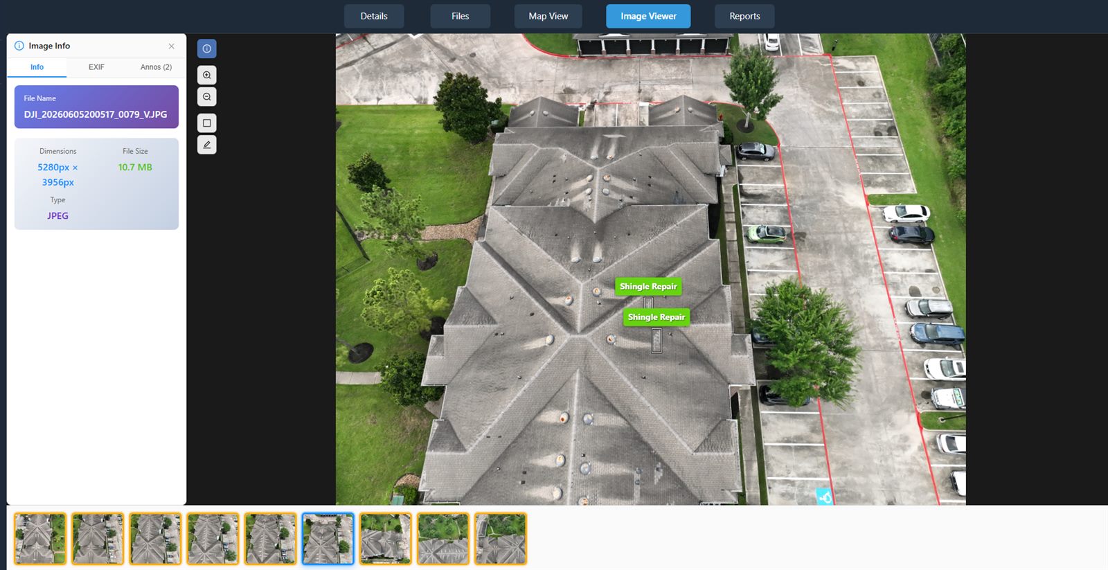
In DataDelivery, full-resolution drone photos open in a deep-zoom viewer in the browser.
How we compared
We make DataDelivery, so it appears in this list. For each tool we checked three things on the vendor's own website: which operating systems it runs on, what it costs, and how it shares results with clients. We list a fact only if the vendor's own page states it. If we could not confirm something, we say so.
Every tool fact was checked on on the vendor's own site. Sources are listed at the end of this page.
Three ways to map on a Mac
A Mac user has three routes: a desktop app that runs on macOS, a tool that runs in a web browser, or a Windows computer for the tools that have no Mac version.
1. Desktop apps that run on macOS
These install on your Mac, and your own computer does the processing. If you want a desktop app, you have real choices.
Agisoft Metashape
Metashape 2.3.2 has a macOS installer (.dmg) for both Standard and Professional. Agisoft also offers Windows and Linux installers. It is a native Mac option.
Price, checked : Standard $179 and Professional $3,499, each a node-locked license.
PIX4Dmatic
Pix4D says PIX4Dmatic supports both Windows and macOS. On a Mac it needs macOS Sequoia (15) or newer and an Apple M1 chip or newer. Intel Macs stay on an older version.
Price, checked : Analyst $229 a month or $2,290 a year; Standard $399 a month or $3,990 a year; Pro $499 a month or $4,990 a year.
WebODM
WebODM is free, open-source mapping software that you run yourself. Its macOS installer needs macOS 13 or newer, supports Apple silicon, and sets WebODM up using Docker. There are also Windows and Linux versions.
Price, checked : free.
2. Browser-based tools
These run in a web browser, so you can use them from a Mac.
DataDelivery
DataDelivery runs in your web browser, with nothing to install. You turn drone photos into maps with NDS Processing and share the results with clients from the same job. There is more detail in Where DataDelivery fits below.
Pix4D describes PIX4Dcloud as an online platform for drone mapping, progress monitoring and site documentation that you can reach from any device. Starter, Pro and Enterprise all include unlimited users. Its share links open without a login, either to view and measure or to edit and save. People using a link cannot download outputs.
Price, checked : Starter $129 a month or $1,290 a year; Pro $449 a month or $4,490 a year; Enterprise is a custom price.
DroneDeploy
DroneDeploy runs in a web browser. Its help center recommends the latest version of Google Chrome on a laptop or desktop, and says Edge, Safari and Firefox give limited performance. Paid accounts can share a view-only link for each map date that opens without a DroneDeploy login.
Price, checked : Flight & Analysis is $4,188 billed yearly. For other plans, contact DroneDeploy.
Maps Made Easy
Maps Made Easy is an online service: you upload your photos and it processes them for you. It offers branding-free map sharing for paid jobs.
Price, checked : a free tier of 3 maps per 24 hours, 1 free processing gigapixel and up to 50 images per map; subscriptions are Base $5 a month, Pro $15 a month and Elite $45 a month.
3. Windows tools with no Mac version
These tools do not list a macOS version. If you work on a Mac, the two groups above are the ones to look at.
DJI Terra
DJI says DJI Terra needs Windows 10 or later (64-bit) and is not compatible with other operating systems, such as macOS. It also needs an NVIDIA graphics card.
Price on the US DJI Store, checked : Standard $1,850 a year or $5,280 permanent; Flagship $3,700 a year or $10,580 permanent.
RealityScan
Epic says RealityScan runs mainly on Windows. A Linux version is also available, but Epic recommends it only for command-line work. No macOS version is listed, and it needs an NVIDIA graphics card with CUDA.
Price, checked : free if your revenue is under $1 million (USD); $1,250 per seat per year above that.
OpenDroneMap installers
OpenDroneMap sells installers for Windows as a one-time purchase. Its download page says there is currently no Mac installer. WebODM, listed above, is a separate project with its own free Mac installer.
Price, checked : Standard $64 and Business $149.
iTwin Capture Engine
Bentley lists Windows 11 (x64) or Windows Server 2022 (x64) for iTwin Capture Engine.
Price, checked : from $4,000 for a 12-month subscription (one license).
Mac drone mapping tools compared
Operating systems, prices and sharing were checked on on each vendor's own site.
Mac drone mapping tools compared, checked
Tool
Runs on (source)
Price (October 7, 2026)
Client sharing
Agisoft Metashape 2.3.2
macOS (.dmg), Windows and Linux (Agisoft download page)
Standard $179, Professional $3,499 (node-locked license)
Not covered on the pages we checked
PIX4Dmatic
macOS Sequoia (15) or newer on Apple M1 or newer; Windows 11 (Pix4D hardware article)
Analyst $229 a month, Standard $399, Pro $499; yearly $2,290, $3,990, $4,990
Not covered on the pages we checked
WebODM
macOS 13 or newer (set up with Docker), Windows 10 or newer, Linux (WebODM download page)
Email invites with no per-seat fees, or a no-login link, including on the Free plan
PIX4Dcloud
Online, from any device (Pix4D product page)
Starter $129 a month or $1,290 a year; Pro $449 a month or $4,490 a year; Enterprise custom
No-login links to view and measure; link users cannot download outputs; unlimited users
DroneDeploy
In a web browser; Chrome recommended (DroneDeploy help center)
Flight & Analysis $4,188 billed yearly; other plans: contact DroneDeploy
No-login view-only link per map date on paid accounts; a whole-project public link only on Enterprise project packages
Maps Made Easy
Online: you upload photos and it processes them (Maps Made Easy site)
Free tier of 3 maps per 24 hours; Base $5 a month, Pro $15, Elite $45
Branding-free map sharing for paid jobs
DJI Terra
Windows 10 or later (64-bit) only; not compatible with macOS (DJI Terra FAQ)
Standard $1,850 a year or $5,280 permanent; Flagship $3,700 a year or $10,580 permanent (US DJI Store)
Not covered on the pages we checked
RealityScan
Windows; Linux for command-line work; no macOS version listed (Epic requirements page)
Free under $1 million (USD) revenue; $1,250 per seat per year above that
Not covered on the pages we checked
OpenDroneMap installers
Windows; no Mac installer (OpenDroneMap download page)
Standard $64, Business $149, one-time purchase
Not covered on the pages we checked
iTwin Capture Engine
Windows 11 or Windows Server 2022 (Bentley product page)
From $4,000 for a 12-month subscription
Not covered on the pages we checked
"Not covered on the pages we checked" means we did not verify it for this page. It does not mean the tool cannot share results.
Where DataDelivery fits
Best for: Mac users who want processing and client delivery with nothing to install.
DataDelivery runs in your web browser, so there is nothing to install on your Mac.
Processing
NDS Processing turns overlapping drone photos into map products, with five goal presets: Default, Orthophoto / 2D Mapping, 3D Model, Buildings / Structures, and Terrain & Volumes.
It works from standard overlapping JPG or PNG drone photos, ideally from an automated mapping flight with 60 to 80 percent overlap.
Each run produces a stitched orthophoto, elevation models (DSM and DTM), a 3D point cloud, contour lines and a textured 3D model.
See an estimated processing time before you start, then a live status card through each step. You can close the tab.
Every plan, including Free, includes daily NDS Processing runs; higher plans include more.
Viewing and sharing
Orthomosaics open on an interactive map in the browser: pan, zoom, swap the basemap and fade the overlay.
3D point clouds open in the browser: orbit and zoom through the site, and download the LAS or LAZ file.
Share any job with a client by email. There are no per-seat fees: people you share with do not need a paid plan.
Send a no-login link, including on the Free plan: anyone with it can view the job's files, maps and imagery in a browser, with no account and nothing to install. No-login links are view-only by default; invited clients you add to a job can download the files you allow. Point clouds are switched on per link.
Public links expire after 90 days by default, and you can move the date. See how many times each link was opened, and revoke it instantly.
Limits to know
Only the orthomosaic (GeoTIFF) and the point cloud (LAS or LAZ) can be downloaded. Elevation models, contours and the 3D model are for viewing in the browser.
NDS Processing uses five goal presets and has no coordinate-system picker. If you want to fine-tune processing settings yourself, a desktop app may suit you better.
The number of processing runs per day depends on your plan.
Yes. Agisoft Metashape and PIX4Dmatic have macOS versions, and WebODM has a free macOS installer. Browser-based tools such as DataDelivery, PIX4Dcloud, DroneDeploy and Maps Made Easy run in a web browser. DJI Terra, RealityScan, iTwin Capture Engine and the OpenDroneMap paid installers do not list a macOS version. We checked all of this on October 7, 2026.
Is DJI Terra available for Mac?
No. DJI says DJI Terra needs Windows 10 or later (64-bit) and is not compatible with macOS. It also needs an NVIDIA graphics card. On a Mac, look at the desktop apps that run on macOS or at a browser-based tool instead.
Does PIX4Dmatic run on a Mac?
Yes. Pix4D says PIX4Dmatic supports both Windows and macOS. On a Mac it needs macOS Sequoia (15) or newer and an Apple M1 chip or newer.
Is there free drone mapping software for Mac?
Yes. WebODM is free, open-source software with a macOS installer for macOS 13 or newer. You install it and run it on your own computer. For more options, see our guide to free drone mapping software.
Do my clients need special software to see the maps?
Not with DataDelivery. Send a no-login link, including on the Free plan: anyone with it can view the job's files, maps and imagery in a browser, with no account and nothing to install. No-login links are view-only by default; invited clients you add to a job can download the files you allow. You decide per link whether point clouds are included, and they start switched off.
Can I make an orthomosaic in a web browser on my Mac?
Yes, with a browser-based tool. In DataDelivery, NDS Processing turns overlapping JPG or PNG drone photos into a stitched orthophoto, elevation models (DSM and DTM), a 3D point cloud, contour lines and a textured 3D model. You see an estimated processing time before you start, and you can close the tab.
Tool features and pricing were last reviewed on October 7, 2026 using publicly available vendor documentation. Product details may change. DataDelivery and National Drone Services are not affiliated with or endorsed by the other vendors on this page. Product names are trademarks of their respective owners. Where a vendor's pricing is quote-based or custom, we say so rather than estimate a figure.