The Drone Data Platform for Client Delivery

Host, process, and deliver aerial data through client portals. Orthomosaics, point clouds, map-based browsing, time-series comparison, and annotations. Start free.

Purpose-Built for Aerial Data

Generic file sharing works for documents, not aerial data. DataDelivery organizes work by property, site, and date, and adds map-based browsing, point cloud viewing, time-series comparison, annotations, and reports.

Feature DataDelivery™ Dropbox/Drive
Client-ready job portal - Interactive, shareable link (no login required) ✅ ⚠️ file links; no map or LAS viewing See the Dropbox comparison
Image Processing - Generate orthomosaics and point clouds from your raw imagery ✅ ❌
Purpose-built Viewers - View orthomosaics, point clouds, 360° panoramas, videos, and standard imagery all in one place ✅ ⚠️ photos and video; no LAS point clouds
Map-based Viewing - View images based on where they are in reality ✅ ❌
Compare Over Time - Easily see changes between captures ✅ ❌

How DataDelivery™ Works

Your workflow stays the same. Your clients get a better experience.

1

Capture

Fly your job, prepare your deliverables - same workflow you use now.

2

Upload & Organize

Drag and drop files into organized folders. Keep your files organized by capture. Supported files: 360° panoramas, standard images (JPG/PNG), MP4 videos.

3

Process

Use our built in image processing tool to generate orthomosaics and point clouds from your raw imagery.

4

Share

Invite your client by email or send a no-login link. They open the job in a browser with nothing to install, and you can revoke links anytime. Preview Mode shows invited clients a watermarked capture with download buttons hidden.

5

Review & Measure

Compare dates, add annotations and measurements, and build interactive reports. Download whole folders or single files, and see what each invited client opened and downloaded.

Recurring jobs?

Add captures to existing jobs. Clients you invite can compare any two dates to see progress, changes, or issues - perfect for construction monitoring and property management.

Built for Professional Delivery

Purpose-built viewers and tools that make your drone data more valuable and your delivery process more efficient.
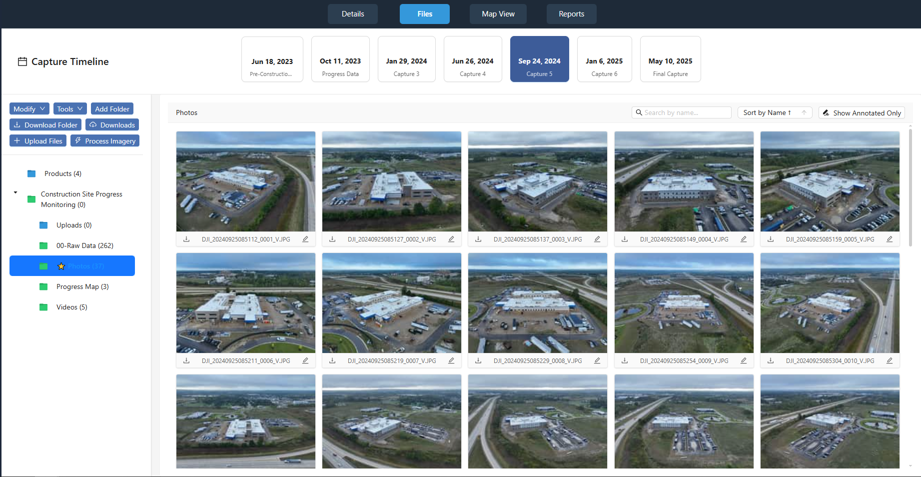
DataDelivery files tab showing capture timeline and organized imagery grid

Example job showing multiple captures organized by flight date.

Capture-Based Job Organization

Each job is structured into individual captures, with every flight you make organized by date. This keeps photos, videos, panoramas, and processed outputs cleanly separated and easy to manage as jobs grow.

Date-Based Organization

Every flight is organized by capture date, making it easy to track progress over time and compare different flight sessions.

Photos, Video and Maps Together

Photos, videos, maps, and processed outputs are cleanly organized within each capture, keeping your job structure clear and manageable.

Image Processing

Generate orthomosaics and point clouds from your raw drone imagery without leaving the platform. Upload photos from a flight, run the built-in processing pipeline, and deliver georeferenced outputs to your clients—no separate photogrammetry software required.

Orthomosaics & Point Clouds

Process raw imagery into 2D orthomosaics and 3D point clouds. Outputs are georeferenced and ready to view on the map or share with clients.

In-Platform Workflow

Keep capture, processing, and delivery in one place. Processed outputs appear in the same job and capture structure for seamless client delivery.
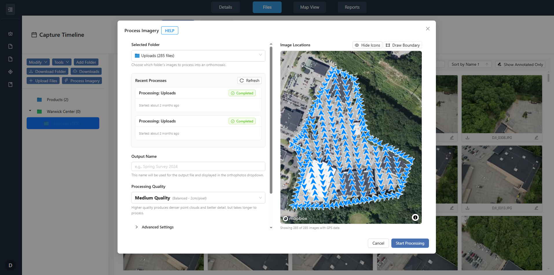
DataDelivery image processing interface for generating orthomosaics and point clouds
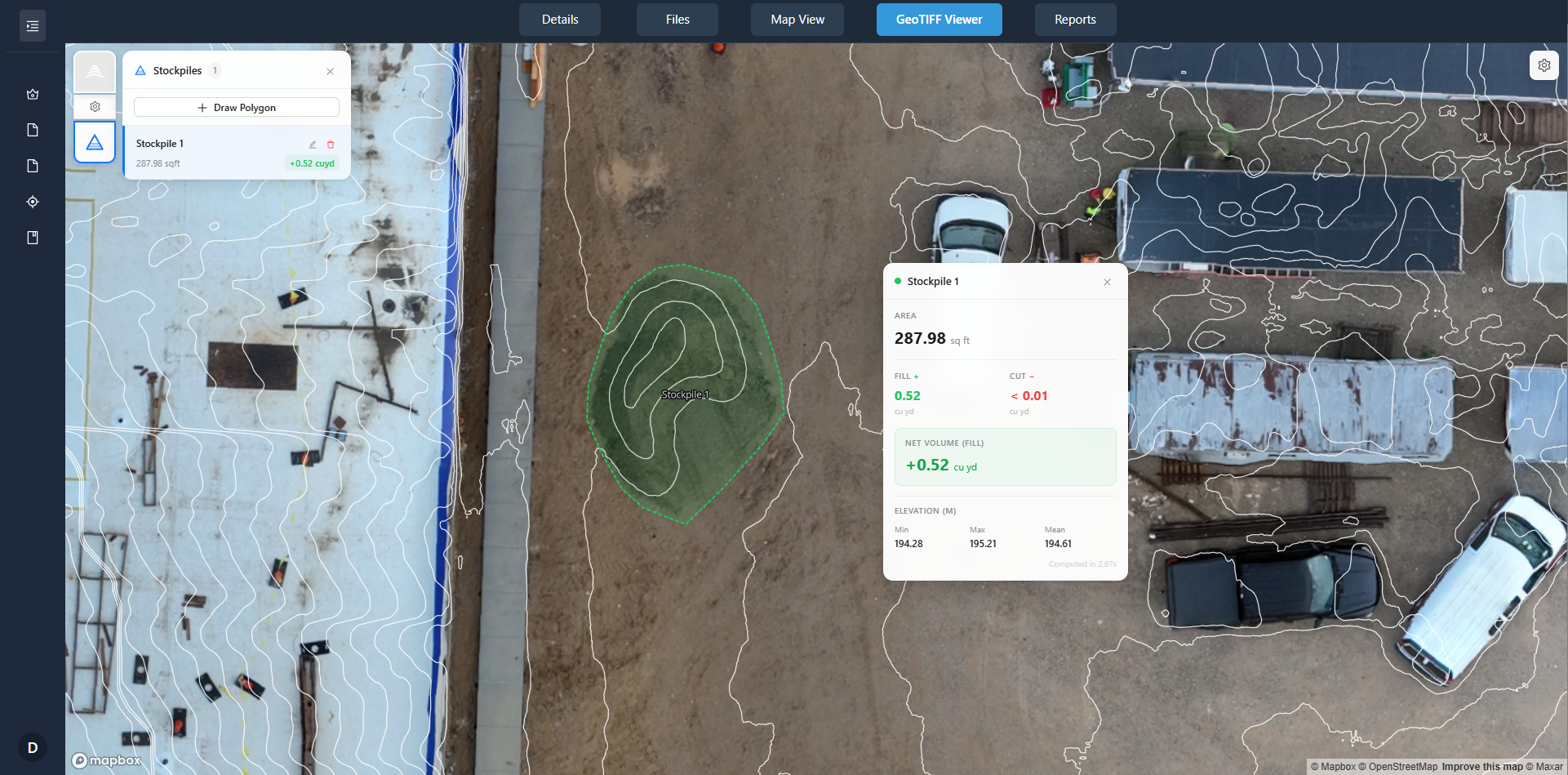
Stockpile measurement and volume tracking in DataDelivery

Stockpile Measurement & Tracking

Estimate stockpile volumes from your aerial data. Capture sites over time, process your photos into an orthomosaic and elevation model, and share the estimates with clients in the same platform you use for delivery.

Volume from Aerial Data

Trace the base of a pile on the orthomosaic to estimate fill, cut and net volume. This needs an elevation model (DSM), from NDS Processing or imported. Results are estimates for inventory tracking, not surveyed quantities.

Time-Series & Reporting

Add recurring captures to the same job and measure each visit. Share results with clients in a report or through the same portal you use for imagery.

Map-Based Viewer

Clients view orthomosaics and site imagery on an interactive map. Click any image to view full-screen, add annotations, and explore the data - all without leaving the portal.

Map-Based Browsing

Orthomosaics display on a map using embedded geospatial data. Navigate by location, not file names. Organize by property, site, and date.

Image Annotations

Mark issues and add notes on imagery, then add annotated imagery to a report you build.
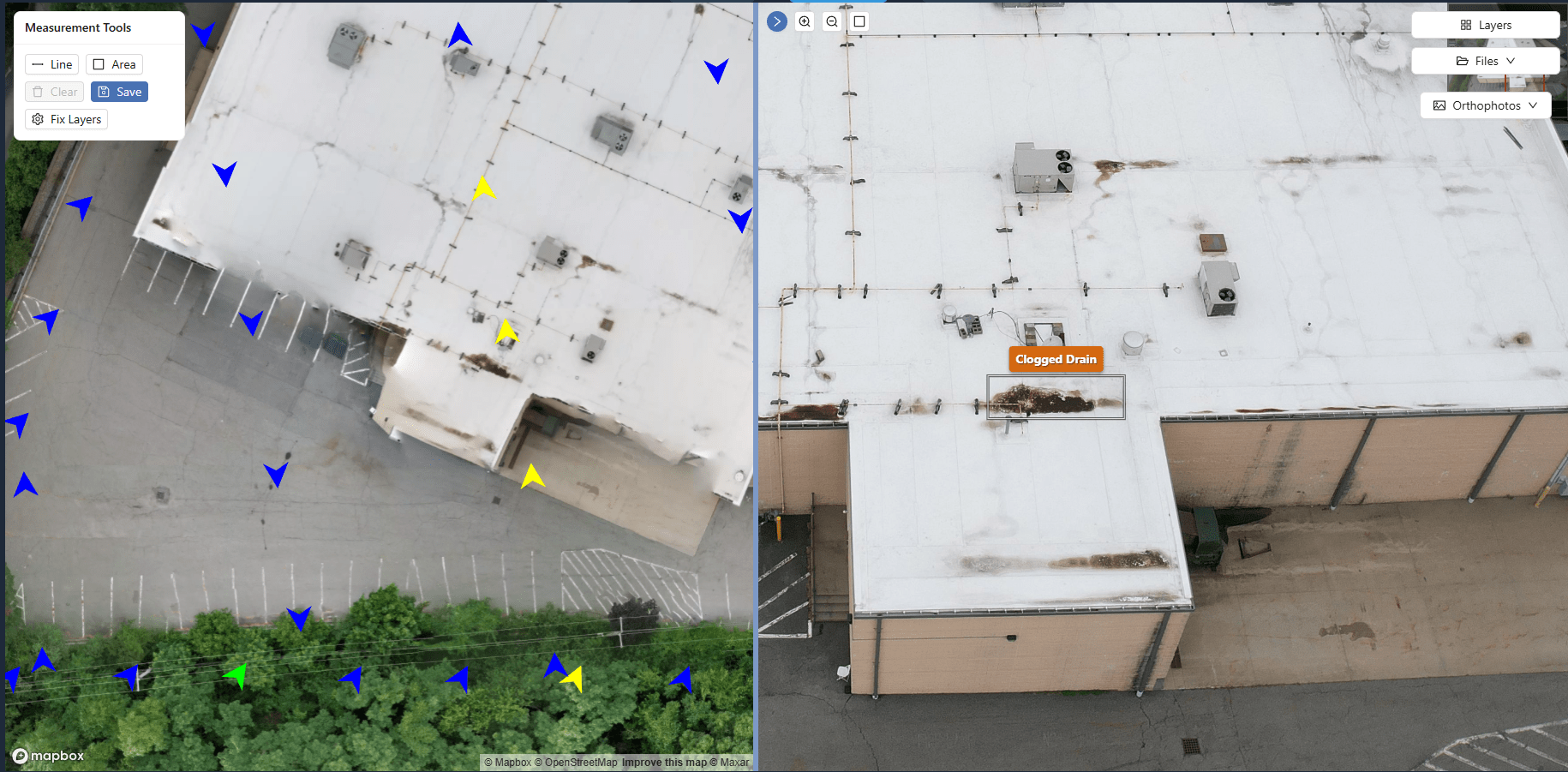
Interactive map annotations showing full-screen image with annotation tools
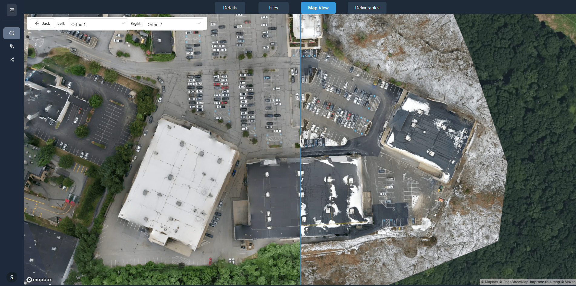
Before and after slider comparing orthomosaics from two capture dates

Time-Based Comparison

For recurring jobs, compare any two orthomosaics with a before and after slider. Clients you invite can see construction progress, site changes, or maintenance issues between visits. This is useful for construction monitoring and property management.

Before and After Slider

Clients select two dates from the capture timeline and compare the orthomosaics with a before and after slider.

Recurring Capture Support

Add new captures to existing jobs. Each capture is date-stamped and organized chronologically - no manual file management required.

Progress Documentation

Clients document progress over time without downloading files or managing versions. All captures are accessible in one portal.

Measurement Tools

Measure distance, area and perimeter directly on orthomosaics. Results show in meters and feet, and figures are approximate. Useful for site planning and area estimates.

Area Measurements

Draw a polygon on the orthomosaic to get its area and perimeter. Area shows in square meters, hectares and acres.

Multiple Measurement Layers

Save measurements as named layers for each site visit (parking, landscaping, buildings). Each layer can be toggled on/off and exported on its own.

Measurement Export

Export each measurement layer as GeoJSON, or include measurements in interactive reports. GeoJSON keeps the coordinates for use in GIS software.
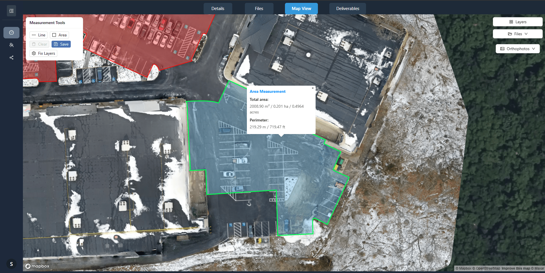
Map view showing multiple area measurements with detailed popup displaying area and perimeter calculations

Deliver under your brand, on your domain

On Premium and Enterprise, deliver from your own address, such as portal.yourcompany.com, with your logo and business name. Share emails, job links and report links use your domain.

  • ✅ Custom domain (portal.yourcompany.com)
  • ✅ Your logo and business name on client pages and emails
  • ✅ No "Powered by DataDelivery" link on Premium and Enterprise
  • ✅ Available on Premium and Enterprise plans
Start Free — Upgrade Anytime
Your Client Portal
portal.yourcompany.com
📍 Map View
🗂️ File Browser
🔄 Time-Series
📊 Reports

DataDelivery™ vs DroneDeploy

How client delivery compares.

Feature DataDelivery™ DroneDeploy Dropbox/Drive
Starting price Free plan (see all plans) See current DroneDeploy pricing Free tier available
Free plan available ✅ ❌ ✅
No-login client portal ✅ including the Free plan ⚠️ view-only link per map date, on paid plans ⚠️ file links; no map or LAS viewing
White-label custom domain ✅ Premium and Enterprise Not described in DroneDeploy's sharing documentation Dropbox: no custom domain
Ortho + point cloud processing ✅ ✅ ❌

Competitor features were last reviewed on 2026-10-07 using publicly available vendor documentation. Product details may change. DataDelivery and National Drone Services are not affiliated with or endorsed by DroneDeploy, Dropbox or Google. DroneDeploy, Dropbox and Google Drive are trademarks of their respective owners.

Looking for a DroneDeploy alternative? Compare DataDelivery.

Client Job Portal

Easily curate a custom portal for your client to view their data.

Increase your credibility by delivering a polished, client-facing portal where stakeholders can explore imagery, review annotations, and quickly see change over time — without downloading anything.

Shareable link (no login required)

Send one URL, revoke anytime

Map-first viewing

Clients click where issues are, not filenames

Interactive annotation deliverables

Clean, structured layouts that feel like a professional report

Progress & before/after comparisons

Perfect for recurring construction or inspection work

Explore DataDelivery by Workflow

Deeper guides for the specific ways drone service providers process, present, and deliver data to their clients.

Deliver data through a professional client portal

Give customers access to photos, maps, models, reports, and project files in one organized location.

Explore the drone client portal →

Deliver every project under your brand

Use a branded customer experience rather than sending generic file-storage links.

Explore white-label delivery →

Share orthomosaics in a browser

Let clients view large mapping deliverables without requiring specialist desktop software.

Learn how to share orthomosaics →

Let clients explore point clouds

Provide browser-based access to 3D point-cloud data and supporting project files.

Explore the point-cloud viewer →

Track construction progress

Organize repeat captures, maps, imagery, reports, and project history.

Explore construction progress →

Measure and report stockpile volumes

Process drone data, calculate measurements, and deliver results professionally.

Explore stockpile measurement →

Compare and guides

Compare your options, see how to deliver drone data, and connect the software you already use.

Deliver Data to Clients Securely

You decide who can open each job, what they can do, and how long links last.

Access Control

  • Permission levels: Give each person Viewer, Contributor, Editor or Full access, or pick individual permissions.
  • Change or remove access: Removing someone ends their signed-in access right away. No-login links are managed and revoked separately.
  • Activity: See what each invited client opened and downloaded. No-login link visits show as a view count.

Link Controls

  • Secure share links: No-login links expire after 90 days by default. You can move the date or revoke a link instantly.
  • Downloads are your choice: No-login links are view-only by default; invited clients you add to a job can download the files you allow. You decide per link whether point clouds are included, and they start switched off.
  • Link privacy: No-login links show only the job's content. Billing details, who else has access and your other jobs are never included.

Pricing

Choose the capacity that matches your job volume. You can upgrade, downgrade, or cancel any time.

Five plans, from Free to Enterprise. No per-seat fees, and every plan, including Free, includes daily NDS Processing runs.

See full pricing & plans →

All plans include:

Map-based navigation Time-based comparisons Annotations & reports Secure client portal

DataDelivery™ FAQs

What file formats are supported?

Photos (JPG and PNG), 360 panoramas and PDFs open in the browser, and so do videos in common formats such as MP4 (HEVC plays where the browser supports it). You can also store and deliver other handoff files, such as KML, GeoJSON, DXF and 3D models. Some of these are download-only. Finished orthomosaics, elevation models and point clouds (.tif, .tiff, .las, .laz) go through Add External Products, so they become map and 3D layers. YouTube or Vimeo links can sit in a folder next to your deliverables.

How do recurring captures work?

Add new captures to existing jobs. Each capture is date-stamped and organized chronologically. Clients you invite can compare the orthomosaics from any two dates with a before and after slider.

Can I let my clients preview the imagery?

Yes. Preview Mode shows signed-in clients a capture with a PROOF watermark and hides download buttons until you switch it off. It works for clients you invite by email, not for no-login links.

How is client access controlled?

Each person you invite gets a permission level, from Viewer to Full access. You can see what each invited client opened and downloaded, and change or remove their access at any time. No-login links are managed and revoked separately.

Do you support point clouds?

Yes. NDS Processing produces a 3D point cloud alongside the orthomosaic, and you can import LAS or LAZ files from other software. Point clouds open in the browser, where clients can orbit, zoom and measure distance, height, area and angle.

Can clients download files?

Yes, if you allow it. Invited clients with download permission can download single files, whole folders or selections, and big folders are zipped in the background. No-login links are view-only by default.

Ready to Use the Platform?

Organize by property, site, and date. Map-based browsing, point clouds, time-series comparison, annotations, and reporting - all in one platform.