Free Drone Mapping Software: What You Actually Get

Free mapping tools cost nothing up front, but each comes with a limit: a daily cap, an image cap, no exports, or a computer you have to supply. Here is what each free option includes, checked on each vendor's own site.

Free plan, no credit card required.

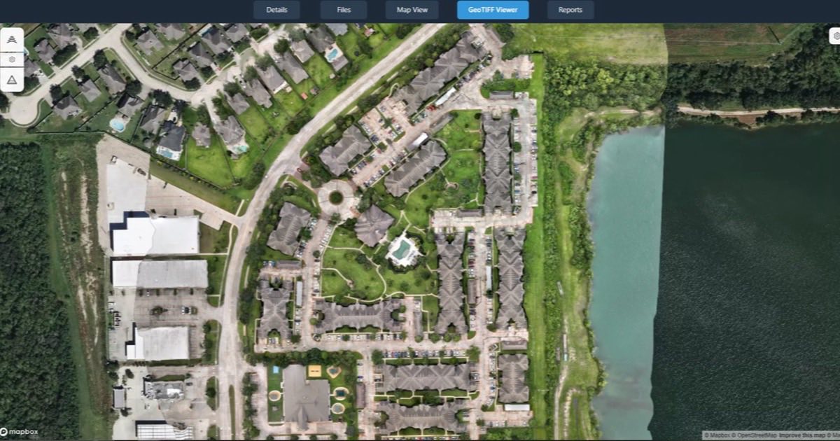
An orthomosaic of a residential site open on an interactive map in DataDelivery
An orthomosaic open on the DataDelivery map, in a web browser.

How we compared

We make DataDelivery, so it appears in this list. We looked at tools a drone pilot can use to make maps or 3D models for free, or with a free tier. For each one we checked the vendor's own site for what the free version includes, its limits, how you can share results with a client, and what the first paid step costs. Where we could not confirm a detail, the table says "Not checked". We did not test processing speed or output quality.

Every tool fact was checked on on the vendor's own site. Sources are listed at the end of this page.

Free drone mapping tools at a glance

Free drone mapping tools at a glance, checked October 7, 2026
Tool Best for What the free version includes Client sharing First paid step
DataDelivery (Free plan) Processing and client delivery in one browser tool 1 new job a month, 2 captures per job, 1 processing run a day, 25 GB, no credit card Email invites, or a no-login link (included on the Free plan) Starter: $12.99 a month or $129 a year, as of
WebODM Pilots who are happy to install and run their own software Free and open source. Installers for Windows and macOS; Linux runs it with Docker Depends on how you host it WebODM Lightning cloud plans from $24 a month, billed yearly
Maps Made Easy Small maps processed online, a few at a time 3 maps per 24 hours, 1 processing gigapixel, up to 50 images per map Branding-free map sharing on paid jobs Base: $5 a month or $50 a year
Agisoft Cloud Metashape Professional users who want cloud storage and processing 50 GB of storage and 20 processing hours a month. Processing needs Metashape Professional Not checked Agisoft Cloud: from $10 a month per 100 GB, plus $4.25 per processing hour, as of
RealityScan Desktop photogrammetry on a Windows PC with an NVIDIA graphics card Free if your revenue is under $1 million (USD) Not checked $1,250 per seat per year above $1 million revenue
SkyeBrowse (Freemium) Trying SkyeBrowse 3D models before paying per model 2 concurrent models, a 30-day archive, no exports Not checked Commercial: $24.99 per model
Polycam (Free) Small 3D captures shared by public link Up to 150 images per model, GLTF exports, limited captures Public link sharing Basic: $150 a year or $30 a month

The free options, one by one

DataDelivery Free plan

Best for: pilots who want processing and client delivery in one browser tool, with nothing to install.

  • Start free: 1 new job a month, 2 captures per job, 1 processing run a day and 25 GB of storage. No credit card.
  • NDS Processing turns overlapping drone photos into map products, with five goal presets: Default, Orthophoto / 2D Mapping, 3D Model, Buildings / Structures, and Terrain & Volumes.
  • Each run makes an orthomosaic, elevation models (DSM and DTM), a 3D point cloud, contour lines and a textured 3D model. You can download the orthomosaic GeoTIFF and the LAS/LAZ point cloud. The elevation models, contours and 3D model are for viewing in the browser.
  • Share with clients by email invite, or send a no-login link, including on the Free plan.

Limits: one new job a month and one processing run a day are real caps. Paid plans add more jobs, captures and storage, and higher plans add more processing runs a day. Self-hosted tools have no daily allowance, but you supply the computer.

WebODM (self-hosted)

Best for: pilots who are happy to install and run their own processing software.

  • WebODM is free, open-source software (AGPL-3.0) for processing drone photos. It is a third-party project.
  • Free installers: Windows 10 or newer; macOS 13 or newer, including Apple silicon (the installer sets WebODM up with Docker); and Linux through Docker.
  • If you would rather not host it, WebODM Lightning is a paid cloud service, from $24 a month billed yearly.

Limits: you install and run it yourself, on a computer or server you supply.

Maps Made Easy (free tier)

Best for: small maps processed online, a few at a time.

  • Free tier: 3 free maps per 24 hours, 1 free processing gigapixel, and up to 50 images per map with no downscaling.
  • You upload your photos and Maps Made Easy processes them online.
  • Paid jobs get branding-free map sharing.

Limits: the free tier stops at 50 images per map. Base costs $5 a month or $50 a year, with up to 200 images per map and 7 maps per 30 days.

Agisoft Cloud (free tier)

Best for: Metashape Professional users who want cloud storage and processing.

  • Free: 50 GB of storage plus 20 processing hours, renewed each month.
  • Processing in Agisoft Cloud needs Metashape Professional installed with a valid license key. Trial and educational licenses count.
  • Metashape 2.3.2 has installers for Windows, macOS and Linux.
  • Metashape Standard costs $179 and Professional costs $3,499, each a node-locked license. Standard is low-cost, not free.

Limits: without a Professional license (a trial or educational license counts), the free cloud hours cannot be used for processing.

RealityScan

Best for: desktop photogrammetry on a Windows PC with an NVIDIA graphics card.

  • Free if your revenue is under $1 million (USD). Above that, it costs $1,250 per seat per year.
  • It runs primarily on Windows. A Linux version is available but is recommended only for command-line workflows. No macOS version is listed.

Limits: it needs an NVIDIA graphics card with CUDA.

SkyeBrowse Freemium

Best for: trying SkyeBrowse 3D models before paying per model.

  • Freemium: 2 concurrent models, a 30-day archive, drawing, distance and annotation tools, and image walkthroughs.
  • Commercial costs $24.99 per model with 3 months of storage. Pro costs $49.99 per model with 1 year of storage and custom white labeling.

Limits: no exports on Freemium, and 2 models at a time.

Polycam Free

Best for: small 3D captures you want to share by public link.

  • Free: up to 150 images per model, GLTF exports and public link sharing, with a limited number of captures.
  • Basic costs $150 a year or $30 a month, with up to 300 images per model.

Limits: 150 images per model on the free plan.

Other free and open-source tools

  • COLMAP: free, open-source software (New BSD license) that builds 3D scenes from photos (structure from motion and multi-view stereo). Release 4.2.1 has builds for macOS (Apple silicon) and Windows.
  • Meshroom (AliceVision): a free photogrammetry app under the MPL-2.0 license. The 2025.1.0 release has downloads for Linux and Windows only.
  • OpenSfM: a free command-line library for structure from motion (BSD-2-Clause). Its last tagged release, v0.5.1, is from August 2020.
  • QGIS: free GIS software (GNU GPL) for Windows, macOS and Linux. Use it to view GeoTIFF orthomosaics you already have.

Trials are not free tools

Some well-known platforms offer a trial instead of a free plan. DroneDeploy has a 14-day free trial, and Pix4D has a free 15-day plan. Neither asks for a credit card. Trials are a good way to test a tool, but they end, so we have not listed them as free software.

Comparing paid platforms? See our comparison of DroneDeploy alternatives, with prices.

Create an orthomosaic online

You do not need a powerful computer to make an orthomosaic. Some services process your photos online. In DataDelivery it works like this:

  1. Fly an automated mapping flight. DataDelivery works from standard overlapping JPG or PNG drone photos, ideally with 60 to 80 percent overlap.
  2. Create a job and upload the photos from your browser, with your folder structure kept.
  3. Pick the folders from one site visit, choose a goal preset and start NDS Processing. You can draw a boundary to limit the area, set a contour interval and get an email when it finishes.
  4. See an estimated processing time before you start, then a live status card through each step. You can close the tab.
  5. Open the orthomosaic on an interactive map, then invite your client or send a no-login link.

The Free plan includes 1 processing run a day. For every setting, see the step-by-step processing guide.

Maps Made Easy also processes uploads online, with up to 50 images per map on its free tier. Already have an orthomosaic from other software? You can bring finished maps and point clouds into DataDelivery, then share the orthomosaic with your client.

How to choose a free mapping tool

  • Limits that fit your flights: images per map, maps or runs per day, and storage.
  • Files you can download, not only view: check whether you can take away the orthomosaic GeoTIFF and the point cloud.
  • Client sharing: can your client open the map without buying software?
  • Your computer: desktop tools may need Windows or an NVIDIA graphics card. On a Mac, see drone mapping software for Mac.
  • The first paid step: what you will pay when you outgrow the free tier.

See current DataDelivery plans

Free drone mapping software: common questions

Is there free drone mapping software?

Yes. WebODM is free and open source if you install and run it yourself. Maps Made Easy, Agisoft Cloud, SkyeBrowse, Polycam and DataDelivery have free tiers with limits, and RealityScan is free if your revenue is under $1 million. Agisoft Cloud processing needs a Metashape Professional license.

Can I create an orthomosaic online for free?

Yes, within limits. DataDelivery's Free plan includes 1 processing run a day and 1 new job a month. Maps Made Easy's free tier allows 3 maps per 24 hours, with up to 50 images per map. Both process your photos online, so there is nothing to install.

Which files can I download after processing in DataDelivery?

The orthomosaic as a GeoTIFF and the point cloud as LAS or LAZ. The elevation models (DSM and DTM), contour lines and textured 3D model are view-only in the browser.

Can my client see the map without buying software?

Yes. Invite them by email, and new recipients get a free account and a link to set their password. Or send a no-login link, including on the Free plan. Anyone with the link can view the job's files, maps and imagery in a browser, with nothing to install.

Is DataDelivery's Free plan a trial?

No. There is no time-limited trial. You start on the Free plan with no credit card, and upgrade only if you need more jobs, captures, storage or processing runs.

Make your first map on the Free plan

Free plan, no credit card required.

Tool features and pricing were last reviewed on October 7, 2026 using publicly available vendor documentation. Product details may change. DataDelivery and National Drone Services are not affiliated with or endorsed by the other vendors on this page. Product names are trademarks of their respective owners.

Sources