Keep Your Mapping Software. Deliver with DataDelivery.
Import the orthomosaics, elevation models and point clouds you already make, then deliver them to clients from one DataDelivery job. If you book jobs in DroneCRM, you can connect it too.
Free plan, no credit card required.
What connects to DataDelivery?
DataDelivery has one direct app connection: DroneCRM. For everything else, there are no app-specific connectors. Standard GeoTIFF and LAS/LAZ exports from your photogrammetry software import when they pass the file checks.
Already processed a flight in another program? Import a finished orthomosaic, DSM, DTM (GeoTIFF) and LAS/LAZ point cloud into a DataDelivery job. Each file is checked automatically, then it appears in the Products folder ready to view, measure and share.
File checks and integration details checked on .
The DroneCRM connection
DroneCRM
Book jobs in DroneCRM. The connection can create the matching DataDelivery job and send the photos straight in.
National Drone Services does the processing. You start the run, and NDS Processing turns the photos into an orthomosaic and a 3D point cloud. DroneCRM gets status updates and the client delivery link back.
How the DroneCRM connection worksImport orthomosaics and LAS point clouds into your client portal
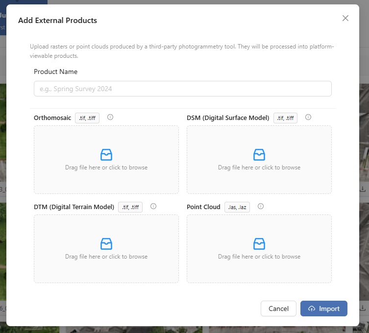
Each finished product has its own slot in the Add External Products window. Fill only the slots you have files for.
Orthomosaic
A finished, stitched map as a GeoTIFF (.tif or .tiff). It opens on an interactive map in the browser: pan, zoom, swap the basemap and fade the overlay.
DSM
A surface model as a GeoTIFF. Import a DSM with your orthomosaic to run approximate stockpile estimates in the browser.
DTM
A bare-ground model as a GeoTIFF. Import a DTM (or a DSM) and DataDelivery can generate contour lines.
Point cloud
A LAS or LAZ file. Upload it and share it online: 3D point clouds open in the browser, so clients can orbit and zoom through the site.
Upload Files is for photos, video and supporting files. Finished orthomosaics, elevation models and point clouds (.tif/.tiff/.las/.laz) go through Add External Products, so they become map and 3D layers. For step-by-step help, read the Add External Products guide.
Still choosing mapping software? Compare free drone mapping software, or see your options for drone mapping software on a Mac.
How imported files are checked
Files are checked automatically. Files that fail are rejected with the reason.
- An orthomosaic needs at least 3 bands and a coordinate system that converts to WGS84.
- A DSM or DTM needs a single elevation band and a standard EPSG code.
- A point cloud must be a real LAS/LAZ file.
- Each slot takes one file, so merge tiled orthomosaic exports into a single file first.
If a file is rejected, see Troubleshooting file checks below.
What imported files get, and what they do not
Imported files get
- The interactive map for orthomosaics, with distance, area and perimeter measurements. Figures are approximate.
- The 3D viewer for point clouds, with distance, height, area and angle measurements.
- Approximate stockpile estimates, when you import a DSM with your orthomosaic.
- Contour lines, generated from a DTM (or a DSM).
- Sharing with your clients, like any other file in the job.
Imported files do not get
- An NDS Processing Report. That report is only for orthomosaics made by NDS Processing.
- A textured 3D model. That comes only from NDS Processing runs.
- Photo annotations projected onto the point cloud. That works only on point clouds made by NDS Processing.
Imported files count toward your plan storage.
After you import
Stockpiles, with a DSM
Trace the base of a pile on the orthomosaic to estimate fill, cut and net volume in cubic yards. Results are estimates for inventory tracking, not surveyed quantities. A DTM alone cannot run stockpiles.
Contours, from a DTM
Generate contour lines from a DTM (or a DSM), keep several sets and restyle them. Contour lines are view-only layers.
Sharing with clients
Share the job with a client by email: new recipients get a free account and a link to set their password. Or send a no-login link, including on the Free plan. No-login links are view-only by default; invited clients you add to a job can download the files you allow. You decide per link whether point clouds are included, and they start switched off.
More on sharing orthomosaics with clients and sharing point clouds with clients.
A timeline of site visits
Each job holds multiple dated site visits (captures) on a timeline, so recurring work stays in one place. Open the right capture before you import, and each visit's products stay with that visit.
Your data is never locked in
Download original files at full resolution, folders as ZIPs, point clouds as LAZ, and map layers as GeoJSON.
Elevation models (DSM and DTM), contour lines and textured 3D models are view-only in DataDelivery, so keep your own copies of the elevation models you import.
Troubleshooting file checks
Why was my orthomosaic rejected for too few bands?
An orthomosaic needs at least 3 color bands (red, green and blue). If the file is an elevation model, drop it in the DSM or DTM slot instead.
Why was my orthomosaic rejected for its coordinate system?
An orthomosaic needs a coordinate system that converts to WGS84 (latitude and longitude). A file with no coordinate system, or one that cannot be converted, is rejected. Export it again from your mapping software with the coordinate system included.
Why was my DSM or DTM rejected for a missing EPSG code?
A DSM or DTM needs a standard EPSG code. Some files keep their coordinate system only in a separate .aux.xml file, or describe it in a form the check cannot read. Reproject the file to a standard EPSG coordinate system, such as EPSG:4326 or your local UTM zone, then import it again.
Why was my DSM or DTM rejected for its bands?
A DSM or DTM must have exactly one band of elevation values. A file with more than one band, or with 8-bit image data instead of elevation values, is rejected.
Why was my point cloud rejected?
The file must be a real LAS or LAZ file. Other point formats renamed to .las are rejected, and so are files with zero points. The file header also needs a spatial reference system (its coordinate system) and scale factors. Export the point cloud again as LAS or LAZ with its coordinate system set.
Can I import a tiled orthomosaic?
Not as tiles. Each slot takes one file, so merge tiled orthomosaic exports into a single GeoTIFF first.
Related
Bring your maps. Deliver them with DataDelivery.
Free plan, no credit card required.
File imports work with standard GeoTIFF and LAS/LAZ files, not through app-specific connectors. DataDelivery and National Drone Services are not affiliated with or endorsed by the makers of other photogrammetry software, and this page does not claim that any particular program's exports will pass the file checks.