A drone does not draw contours. It captures overlapping photos, software turns them into a point cloud and an elevation surface, and contour lines are derived from that surface. Get the flight, the ground model and the checks right, and you can hand a client contours they can trust. DataDelivery™ organizes, processes and delivers that data by property, site and date, and its stockpile and contour measurement tools sit in the same place as the orthomosaic and point cloud.
TL;DR
- Contours come from a terrain model (DTM), not from the photos directly. Ground points are filtered out of a point cloud, the DTM is built, and the lines are derived from it.
- Plan overlap first: professional guidance sets minimums of 80% forward and 70% side overlap.
- Accuracy is proven with independent checkpoints that were left out of the model adjustment.
- Photogrammetry sees surfaces. Dense vegetation can hide bare earth, so state that limit in the deliverable.
- Handoff matters as much as capture: contours, DTM, orthomosaic, point cloud, coordinate system and accuracy report should reach the client in one organized place.
Table of Contents
- What a drone contour map is made of
- Plan the flight for the terrain
- From images to contours
- How accurate are drone contours?
- Vegetation, buildings and other limits
- What to hand the client
- Why recurring contours belong in one platform
- Start delivering contours
- FAQ
- Sources
What a drone contour map is made of
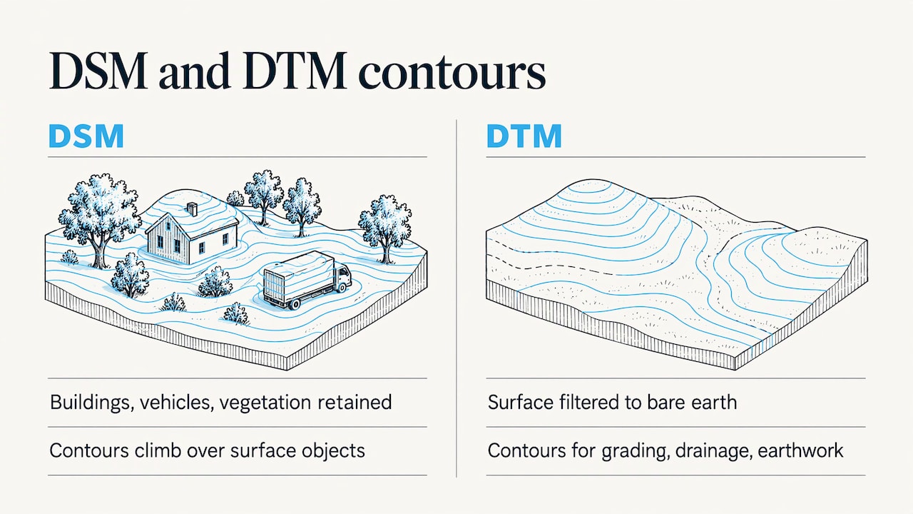
A contour line joins points of equal elevation. To draw one you need an elevation surface, and drone software produces two kinds. Esri’s documentation describes a DSM as an elevation surface that keeps buildings, vehicles and vegetation, and a DTM as a surface filtered to represent the earth itself. Contours for grading, drainage or earthwork are normally cut from the DTM. Cut from the DSM, they climb over every tree and parked truck.
The same processing run also gives you an orthomosaic (a single georeferenced, distortion-corrected image of the site) and a point cloud. DJI’s own guide notes that visible-light 2D reconstruction yields a digital surface model and orthophoto, while 3D reconstruction yields a model or point cloud. Together these are the building blocks of a topographic map.
Plan the flight for the terrain
Most bad contours are decided before takeoff. Settle these first:
- Boundary and outputs. Decide what the client needs: contours at what interval, which accuracy, which file formats.
- Ground sample distance (GSD). This is the ground size of one pixel. Pick altitude and sensor to meet the accuracy you promised.
- Overlap. The Ontario Association of Land Surveyors guide recommends at least 80% forward and 70% side overlap, and a GIS best-practice document gives the same figures for most cases.
- Site visit. The FHWA’s 2019 technical brief on UAS land surveying advises a pre-flight visit to spot obstacles and conflicts, and lists airspace, weather, temperature, terrain, takeoff and landing sites as planning factors.
- Control. Place ground control points (GCPs) and checkpoints so they are spread across the site and across its different elevations.
Slopes need terrain-following
On a hillside, a fixed altitude means the camera is closer to the ground on the high side. GSD and overlap change across the site. The FHWA brief explains that terrain-following flight planning keeps altitude above ground, GSD and overlap relatively constant. A 2023 peer-reviewed study went further and built contour-following flight routes from a DEM to keep shooting distance consistent. For a quarry, landfill or graded pad with real relief, this is worth the extra setup. Our guide on building a drone flight plan covers what to put in the plan itself.
Weather and contingencies
Wind and light affect image quality and overlap, so build a fallback day into the schedule. A weather contingency planning guide is a good starting point for deciding in advance what conditions cancel a flight.
From images to contours
The processing chain is the same whatever software runs it:
- Align the images. Geotagged photos go through aerial triangulation, which solves where each photo was taken.
- Build the point cloud. Esri notes that surfaces are generated from point clouds made by matching overlapping images.
- Classify ground. Filter ground points from vegetation, buildings and equipment.
- Generate the DTM. The surveyors’ guide describes the chain as JPEGs and EXIF data, point cloud, ground classification, DTM, then spot elevations, cross-sections and contours.
- Derive contours. Choose an interval that suits the job. A tight interval on noisy data produces cluttered lines, so match it to the accuracy you can actually support.
- Export. Deliver in the formats the client’s CAD or GIS team uses, with the coordinate reference system stated.
In DataDelivery, orthomosaic and point cloud generation happen in the platform, so you do not need separate image-processing software, and you can measure stockpiles and contours on the result. If you already process elsewhere, you can bring those files in as external products.
How accurate are drone contours?
Accuracy depends on positioning, control and terrain, and it is demonstrated, not assumed.
- RTK or PPK. DJI’s LiDAR guide says point-cloud processing needs centimeter-accurate RTK or PPK, with PPK as the fallback when RTK is unstable.
- Checkpoints. These are surveyed points held out of the adjustment. A case study from a drone manufacturer processed PPK imagery without GCPs and compared 24 independent checkpoints, finding average point-cloud error of 12 mm horizontally and 51 mm vertically. Results like this depend on the equipment and site, so treat them as an example of method, not a promise for your job.
- Spread. DJI recommends distributing elevation checkpoints evenly across the survey and across different elevations, on flat surfaces of at least 1 m by 1 m.
- Independence. The surveyors’ guide stresses quality-control observations independent of the original collection.
Report the result as RMSE (root mean square error, a single figure summarizing how far the model sits from the checkpoints), horizontal and vertical separately.
Vegetation, buildings and other limits
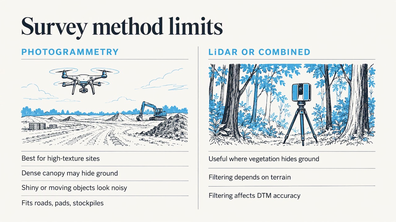
Photogrammetry maps what the camera sees. Under dense canopy it may never see the ground, and shiny, textureless or moving objects can come out noisy. Sensor choice should follow the site: Saudi Arabia’s survey authority notes that photogrammetry suits high-texture sites, while LiDAR or a combined system may be preferable where vegetation hides the ground. Even with LiDAR, a 2023 study found that the ground-filtering method depends on terrain and affects DTM accuracy.
For open construction sites, graded pads, roads and stockpiles, photogrammetry is a strong fit. Where a client needs bare earth under trees, say so in the scope and in the deliverable notes.
What to hand the client
The same Saudi guideline lists what a client-ready package contains: orthomosaic, DSM/DTM, contours, point cloud, CAD/GIS exports, metadata, acquisition report, control and checkpoint results, an accuracy report and known limitations. In the US, TxDOT’s design-grade specification asks for a DTM and TIN, planimetrics, orthoimagery, a triangulation report and an RMSE report, plus classified LAS or LAZ point clouds with metadata.
That is a lot of files per site per visit. Scattered across email and download links, they are hard to compare next month. DataDelivery keeps them under property, site and date, so a client can browse on a map, move through a timeline and open the point cloud in the browser. Our guides on viewing deliverables and sharing point clouds with clients show the client side.
Why recurring contours belong in one platform
A single contour map answers one question. Construction and property teams ask the next one: how much has changed since the last flight? That needs every capture of a site stored consistently, comparable by date, with annotations where something needs attention. DataDelivery supports time-series comparison, annotations and reports, and manages recurring captures. Delivery runs under your brand, without per-seat fees or required client accounts.
What we think
Contours are only useful when the client can open them, compare them with last month’s and act on them. We built DataDelivery around that: one place per site and date for the orthomosaic, point cloud, 3D model and measurements, shared in a portal under your brand.
Providers should spend their time flying and checking accuracy, not stitching together separate processing tools and file-transfer links. Construction teams get progress tracking, and property managers get organized visual documentation.
the author
Start delivering contours
DataDelivery has a free plan at $0 per month. Paid plans are Starter at $12.99 per month or $129 per year, Basic at $29.99 per month or $299.99 per year, Premium at $79.99 per month or $799.99 per year, and Enterprise at $199.99 per month or $1999.99 per year. Limits are based on jobs, processing runs and storage. See the pricing page to match a plan to your volume.

If you need the data captured as well, Turnkey Capture is a per-job service. Learn about Turnkey Capture or explore construction and property management workflows.
FAQ
Do I need ground control points for drone contours?
Not always. With RTK or PPK positioning, some surveys are processed without GCPs. Either way, independent checkpoints should be surveyed and held out of the adjustment, so you can report real accuracy figures.
What is the difference between a DSM and a DTM?
A DSM includes everything on the surface: buildings, vehicles and vegetation. A DTM is filtered to represent the ground. Contours for grading and drainage are normally derived from the DTM.
How much overlap do I need?
Professional guidance sets minimums of 80% forward and 70% side overlap. Complex terrain or low-texture ground may call for more, and terrain-following flight keeps overlap consistent on slopes.
Can a drone map the ground under trees?
Photogrammetry cannot see through dense canopy. LiDAR or a supplementary ground survey is used where bare earth under vegetation is required, and the limitation should be written into the deliverable notes.
Sources
- Product output types, ArcGIS Drone2Map documentation
- DJI Terra Operation Guide v4.2
- Topographic Surveys Guide, Ontario Association of Land Surveyors
- Drones for GIS, Best Practice
- FHWA, Use of Small Unmanned Aerial Systems for Land Surveying
- Contour Mission Flight Planning of UAV for Photogrammetric Applications
- Weather Contingency Planning
- DJI L1 Operation Guidebook
- Survey-grade accuracy drone maps in real-world conditions
- Technical Guidelines for Aerial Surveying, GEOSA
- Enhancing LiDAR-UAS Derived Digital Terrain Models
- TxDOT UAS Aerial Mapping Specifications and Workflow