A good construction site update tells the reader what changed since the last one, what is blocking the work, and what happens next. It does this with evidence they can open and check: dated photos, aerial captures, measurements and short notes, all filed by site and date. Updates fail when they are scattered across texts, email threads and shared folders. We built DataDelivery™ so aerial data, annotations and reports for each property or site live in one place, and clients can open them without creating an account.
This guide is for three readers: drone service providers who deliver site updates to clients, construction firms that track progress, and property managers who need organized visual documentation. It covers what an update should contain, how often to send it, how to keep records comparable over time, and how to turn raw captures into a report a client reads.
TL;DR
- A useful site update covers work completed, current status, issues and risks, safety events, resources and next steps. Photos and aerial captures back up each point.
- Cadence matters. Daily reports, weekly photos and monthly schedule updates serve different purposes, and fast-track jobs need a tighter cycle.
- Comparison is what makes an update valuable. Same site, same angles or flight path, same naming, so any two dates can be viewed side by side.
- Organize by property, site and date from the first capture. Re-sorting a pile of files later costs more than naming them correctly once.
- Deliver in a branded client portal with annotations and a report, not a zip file of images.
Table of Contents
- What a construction site update is for
- What to include in each update
- How often to send updates
- Why aerial captures strengthen site updates
- Organize by site and date from day one
- Turn captures into a report the client reads
- Common problems with site updates, and fixes
- Our perspective
- Get started with DataDelivery
- FAQ
- Sources
What a construction site update is for
A site update documents and communicates progress, problems and next steps at regular intervals. ClickUp’s overview of construction reporting lists the usual contents: work completed, current status, issues or risks, safety incidents, resource tracking, financial updates and next steps. The audience runs from field supervisors to investors, and each one needs a different level of detail.
Think of an update as answering four questions:
- What was done? Footings poured, slab on grade finished, third-floor framing complete.
- Is it on plan? Compared with the schedule and the last update.
- What is in the way? Weather, late deliveries, change orders, inspections, access.
- What do you need from the reader? An approval, a decision, a site visit.
If an update does not help someone decide or act, it is a photo dump. Owners, lenders and tenants do not want 400 images. They want to see that the east wing is a week behind and why.
What to include in each update
The exact fields are usually set by the project contract, the specifications and company practice, so treat the list below as a baseline and adjust it to your agreements.
The written core
- Date, site and reporter. Always. An undated update is nearly useless later.
- Work completed. Specific areas and quantities: “Level 2 deck, gridlines A to D”, not “concrete work”.
- Status against plan. Ahead, on track or behind, with a one-line reason.
- Issues and risks. Open items, who owns them and when they are due.
- Safety events. Incidents, near misses and corrective actions.
- Resources. Crews and equipment on site, and any idle time.
- Next steps. What happens before the next update.
The SYNC construction progress documentation standard calls the daily report the single most important document for substantiating or defending a delay claim. That is a good reason to keep the written core short, consistent and filled out every working day.
If you want a digital tool for the daily log itself, digital inspection reporting tools combine report writing, templates and client portals for field professionals.
The visual record
Photos and aerial captures carry the proof. For each update, plan to include:
- Aerial overview. An orthomosaic, which is a single stitched, map-accurate image of the whole site, shows layout, staging areas, earthwork and access routes at a glance.
- Repeat viewpoints. The same vantage points each time, so change is obvious.
- Detail photos. Close-ups of problem areas, tied to a location on the map.
- Measurements. Stockpile volumes, cut and fill, contours or distances, when they matter to payment or progress.
- Annotations. Arrows, notes and markups that say what the reader should look at.
A caption such as “Retaining wall, north side, forms complete, rebar delivery pending” does more than a gallery of unlabeled images.
How often to send updates
There is no single right interval. The SYNC standard describes layered submittals: monthly schedule updates with a progress narrative, daily construction reports, and periodic progress photographs with metadata. It notes that weekly photography during active construction is the common default. It also says fast-track work, where the critical path has little float (spare time before a delay pushes the finish date), needs a tighter cycle than monthly.
A practical rhythm for most projects:
| Update | Typical interval | Audience | Main content |
|---|---|---|---|
| Daily report | Every working day | Superintendent, project manager, internal record | Labor, equipment, work done, delays, safety |
| Progress photos and aerial capture | Weekly during active work, or at milestones | Owner, project team | Dated visual record of the site |
| Client progress report | Weekly or biweekly | Owner, lender, tenant | Status, visuals, issues, next steps |
| Schedule update | Monthly, or more often on fast-track jobs | Owner, project controls | Progress narrative against the schedule |
Property managers on long-running monitoring work, such as roofs, lots and vacant sites, usually run a lighter schedule: monthly or quarterly captures plus a capture after storms or incidents. Our guide to remote property monitoring with drones covers that routine.
Why aerial captures strengthen site updates
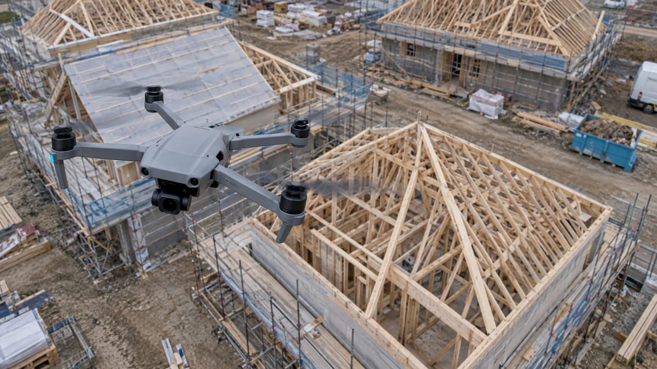
Ground photos show a corner of the site. A drone capture shows all of it, from a consistent angle, in minutes. For a recurring update that matters, because the value comes from comparison: last week’s orthomosaic against this week’s, the original grade against the current contours, the stockpile in March against the stockpile in April.
Aerial data supports several kinds of update content:
- Earthwork progress. Contours and cut and fill measurements.
- Material tracking. Stockpile volumes through drone stockpile measurement with client reporting.
- Site logistics. Laydown areas, access roads, crane positions.
- Milestone documentation. Roof completion, building envelope, paving.
If you want the capture handled for you, our turnkey aerial data for construction covers capture and processing, delivered through the online portal.
Organize by site and date from day one
Most update problems are filing problems. Files named “DJI_0482.JPG” in a folder called “Final v2” cannot be compared with anything.
A workable structure has three levels:
- Property. The client or the asset.
- Site. The specific project or location within the property.
- Date. Each capture or flight, with its deliverables attached.
Once data sits in that structure, three things get easy:
- Map-based browsing. Pick a spot on the site and see everything captured there. Our Map View guide shows how this works in DataDelivery.
- Timeline browsing. Step through dates for one site without hunting for files.
- Side-by-side comparison. Open two dates and see exactly what changed.
This is the main difference between a purpose-built delivery platform and a generic file-sharing tool. A file-sharing tool stores files. A structured platform knows which site and date a file belongs to, so it can compare, annotate and report on it.
Keep captures comparable
Structure only works if the captures match each other:
- Fly the same plan each time. Same area, altitude and overlap.
- Use consistent ground control or reference points, so maps line up across dates.
- Capture at similar times of day when you can, to keep shadows from hiding change.
- Record the capture date, not the upload date.
- Keep outputs consistent. Orthomosaic, point cloud or 3D model, each captured the same way every time.
For recurring jobs, DataDelivery includes recurring capture management, so repeat flights are scheduled and tracked rather than remembered.
Turn captures into a report the client reads
An update has to be easy to open. Clients rarely want to install software or learn a new tool, and they will not read a 200 MB download.
Build the report in five steps
- Start with the headline. One or two sentences: percent complete, status against plan, the biggest issue.
- Show change, not just state. Place the current orthomosaic next to the previous one.
- Annotate. Mark the areas that matter and write the note where the reader will see it. Our annotation guide walks through it.
- Add measurements. Include volumes, contours or distances where payment or scheduling depends on them.
- List next steps and decisions. Name who needs to do what, and by when.
DataDelivery’s reporting tools produce the report from the same data the client views, and shared client portals mean the reader opens a link rather than creating an account. The portal can carry the provider’s own branding, and there are no per-seat fees, so adding another stakeholder does not add cost. See drone client portals and reports for what the client sees, and the guide to reports and sharing for setup.
Point clouds and 3D
For inspections, grading and as-built checks, a point cloud, which is a set of millions of measured points forming a 3D picture of the site, lets the reader measure and inspect in the browser. Our guide to sharing point clouds with drone clients explains how to deliver them without asking the client to install anything.
Common problems with site updates, and fixes
| Problem | What it causes | Fix |
|---|---|---|
| Inconsistent capture angles and flight plans | Dates cannot be compared | Repeat the same plan; schedule recurring captures |
| Files named by camera or by person | Nobody can find a date | Organize by property, site and date |
| Updates with no captions or notes | Readers guess what they are looking at | Annotate and write a headline summary |
| Too many images, no summary | Decision makers stop reading | Lead with status and three to five key visuals |
| Client needs an account or software | Updates go unopened | Share through a branded link-based portal |
| Daily reports skipped or filled out late | Weak record in a delay dispute | Fill out each working day, tied to the site record |
| Different tools for processing and delivery | Hand-offs, delays and version confusion | Process and deliver in one platform |
Our perspective
Most of the update problems we see described come down to two things: the data is hard to find, and the client has to work to see it. Drone work makes this sharper, because every flight produces large files that generic tools were not built to organize.
We built DataDelivery around the way site work is actually reviewed: by property, by site, by date. Put captures into that structure and map browsing, time comparison, annotations and reports follow naturally. Orthomosaics, point clouds and 3D models are generated in the platform, so you do not need separate image processing software.
For drone service providers, that means a delivery experience under your own brand, with no per-seat fees and no accounts for clients. For construction firms and property managers, it means one place to see how a site has changed, and a report built from that same view.
the author
Get started with DataDelivery
If you already capture sites, you can start organizing and delivering them today. DataDelivery has a FREE plan at $0 per month. Paid plans scale with usage limits for jobs, processing runs and storage: Starter at $12.99 per month or $129 per year, Basic at $29.99 per month or $299.99 per year, Premium at $79.99 per month or $799.99 per year, and Enterprise at $199.99 per month or $1999.99 per year. Compare them on the DataDelivery pricing page.
For construction teams that want the flights handled too, see the drone construction progress portal, or learn how to share drone data with clients.
FAQ
How often should I send construction site updates?
Match the interval to the document. Daily reports are written every working day, progress photos are commonly weekly during active construction, and schedule updates are commonly monthly, according to the SYNC progress documentation standard. Fast-track work with little schedule float needs a tighter cycle. Your contract may set the required frequency, so check it first.
What should a construction site update include?
Include work completed, current status, issues or risks, safety incidents, resources and next steps, as described in this construction reporting overview. Add dated photos or aerial captures with captions so readers can see what the text describes. Lead with a one or two sentence summary.
How do I compare site progress over time?
Capture the same area with the same flight plan on a regular schedule, and store each capture by property, site and date. In DataDelivery you can browse by map or timeline and compare dates side by side. That lets the reader see change directly instead of comparing folders of files.
Do clients need an account to view updates?
Not in DataDelivery. Clients open a shared portal link, and the portal can carry your branding. There are no per-seat fees, so adding more viewers does not raise your plan cost.
Sources
- Construction Progress Documentation, SYNC construction standard
- Construction Reporting: Types, Tools, and Best Practices, ClickUp
- Home Inspection Report Software, InspectProHQ