How to Deliver Drone Data to Clients
You finished the flight. Now your client needs the photos, the video, the map and maybe a 3D point cloud. This guide compares the common ways to send drone data, and shows when a simple link is enough and when a client portal makes more sense.
Free plan, no credit card required.
The short answer: match the method to the deliverable
Generic tools are fine for a handful of photos. They get harder to use once a delivery includes large maps, 3D data or repeat visits. Use this table to pick a method for each deliverable.
| What you deliver | Simple option | When a client portal helps |
|---|---|---|
| A few still photos | Email or a shared-folder link works fine. | When the client wants to zoom into full-resolution photos without downloading them, or see on a map where each photo was taken. |
| 4K drone video | A file-transfer or shared-folder link, if the client will download the file. | When the video should play in the browser next to the photos and maps from the same job. |
| Orthomosaic (GeoTIFF) | A download link, if the client has GIS software to open it. | When the client has no GIS software. Orthomosaics open on an interactive map in the browser: pan, zoom, swap the basemap and fade the overlay. |
| 3D point cloud (LAS or LAZ) | A download link, if the client has point cloud software. | When the client should explore the site in a browser instead. 3D point clouds open in the browser, where clients orbit and zoom through the site. |
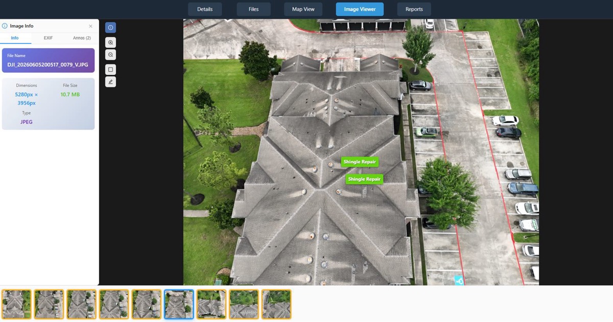
| Photos from your inspections, with your notes | Annotated screenshots in an email or a document you put together. | When clients should see your notes on the photo itself. You mark up photos with rectangles or polygons, each with a name, description and a 1 to 10 severity. |
| A site you fly every month | Dated folders in a shared drive. | When the client wants every visit in one place. Each job holds multiple dated site visits (captures) on a timeline. |
Going deeper on maps or 3D data? See how to share orthomosaics with clients and how clients use the point cloud client viewer.
Common ways to send drone data, compared
Tool limits checked on on each vendor's own help and pricing pages.
- Email: fine for a few small photos. Full-resolution drone photos, video, maps and point clouds are usually too large to attach.
- WeTransfer: recipients do not need an account. The free plan is for individual, non-commercial use only, with 3 GB and 10 transfers a month, and free transfers expire within up to 3 days. The paid Ultimate plan removes the expiry limit.
- Dropbox: built for syncing files across your own computers and phone. It previews .jpg and .png images up to 100 MB or 50 megapixels, and .tif files up to 200 MB or 50 megapixels. GeoTIFF, LAS and LAZ are not on its preview list, and a .tif previews as a plain image.
- Google Drive: previews common image types, including TIFF, as a scaled-down version. Its help page lists no LAS or LAZ point cloud files and no 3D model formats, and says nothing about map views.
- A client portal such as DataDelivery: one no-login link per job covers the files, maps and imagery from every dated site visit. Reports have their own links, and point clouds are switched on per link. No-login links are view-only by default; invited clients you add to a job can download the files you allow.
If you send a few photos once, a free transfer or a shared folder is fine. A portal helps most when you deliver maps, 3D data or repeat visits. Weighing up Dropbox for client work? Read about a Dropbox alternative for drone pilots. Moving off a mapping platform? Compare DroneDeploy alternatives.
A handoff checklist for every delivery
- Name the job and each site visit by date, so the client can find it later.
- Send what the client asked for, plus the original photos if your agreement includes them.
- Tell the client which files open in a browser and which need special software.
- Explain what measurements mean. Measurements are approximate and are not a substitute for a licensed surveyor.
- Decide who can download files, and how long the link should work.
- Keep a record of what you delivered and when.
- Ask the client to confirm they can open everything.
Sending large drone files and 4K video
Full-resolution photos, 4K video and orthomosaics are big. Upload them once and send a link instead of attaching them. In DataDelivery:
- Upload whole folders. Drag in individual files, large batches or whole folders straight from the browser, with your folder structure kept. Uploads retry automatically on network errors.
- Pick up where you left off. Interrupted uploads can be resumed by re-selecting the same folder; files already uploaded are skipped.
- 4K video. Drone videos play right inside the job for common formats such as MP4. MP4 (H.264) plays in the browser; HEVC files play where the viewer's browser supports them, and invited clients with download access can download the original file. Who can download is up to you; see the access controls below.
- Full-resolution photos. Full-resolution drone photos open in a deep-zoom viewer that streams tiles, so clients can zoom to full detail without downloading the original.
- Big downloads. Invited clients with download access can download single files, whole folders or selections. Big folders are zipped in the background, with an email when they are ready.
For a walkthrough of the upload screen, see Uploading Files & Folders in the user guide.
Who can see what: the access controls that matter
Before you send anything, decide who can see it and what they can do. In DataDelivery:
- Permission presets. Viewer (view and download), Contributor (adds upload, annotate, measure), Editor (adds file edits, deleting, reports, processing), Full access (adds managing sharing and job settings), or individual permissions.
- Change or remove access. Change someone's access or remove them at any time. Removal ends their signed-in access right away; public links are managed and revoked separately.
- Link expiry. Public links expire after 90 days by default, and you can move the date. See how many times each link was opened, and revoke it instantly.
- Downloads and point clouds. No-login links are view-only by default; invited clients you add to a job can download the files you allow. You decide per link whether point clouds are included, and they start switched off.
- What a link shows. Public links show only the job's content. Billing details, who else has access and your other jobs are never included.
- Activity. See what each invited client opened and downloaded on a job, from maps and orthomosaics to point clouds, 360 panoramas and reports. Public-link visits show as a view count.
- No passwords. Links have no password, so send each link only to the people who need it, and revoke it when the work is done.
For the bigger picture, see how DataDelivery handles client delivery.
Sending reports with your data
Some clients want a summary, not a folder of files. In DataDelivery you build the report yourself, from the job's own data.
Sharing client reports from the same job
Build interactive web reports from a job's data, choosing and ordering sections such as image comparisons, 2D measurements, annotated imagery, imagery, videos, 360 panoramas, 360 tours, point cloud, stockpiles and custom text. Share any report you build as its own no-login link, and switch it off or revoke it whenever you want.
See how pilots use drone client reports, or how the drone client portal brings reports, maps and photos together for each client.
Step by step: delivering a job with DataDelivery
Create a job for the site
Each job holds multiple dated site visits (captures) on a timeline, so recurring work stays in one place.
Upload your files
Upload Files is for photos, video and supporting files. Finished orthomosaics, elevation models and point clouds (.tif/.tiff/.las/.laz) go through Add External Products, so they become map and 3D layers.
Process or import
NDS Processing turns overlapping drone photos into a stitched orthophoto, elevation models (DSM and DTM), a 3D point cloud, contour lines and a textured 3D model. Already processed a flight in another program? Import the finished files instead. See integrations and file imports.
Invite your client or send a link
Share any job with a client by email: new recipients get a free account and a link to set their password. Or send a no-login link, including on the Free plan. Put your own logo on client-facing pages and emails, starting on the Basic plan. On Premium and Enterprise, deliver from your own address, such as portal.yourcompany.com. Pages on Free, Starter and Basic show a small "Powered by DataDelivery" link. Premium and Enterprise remove it. Learn more about the white-label drone portal.
Track activity
See what each invited client opened and downloaded. Public-link visits show as a view count.
If you book jobs in DroneCRM, the connection can create the job and send the photos in for you. See the DroneCRM integration.
Delivering drone data: common questions
What is the best way to share drone footage with clients?
For a one-off video the client will download, a file-transfer or shared-folder link is fine. If the client should watch it in the browser next to the photos and maps from the same job, use a client portal. In DataDelivery, MP4 (H.264) plays in the browser; HEVC files play where the viewer's browser supports them, and invited clients with download access can download the original file.
How do I send large drone files to a client?
Upload them once and send a link instead of attaching them. In DataDelivery you can drag in whole folders from the browser, uploads retry automatically on network errors, and an interrupted upload can be resumed by re-selecting the same folder.
How do I send drone photos to a client?
For a few photos, email or a shared folder works. For a full set, upload them to a job and send one link. Full-resolution photos open in a deep-zoom viewer, so the client can zoom to full detail without downloading the original.
Can my client open an orthomosaic without GIS software?
Yes, in DataDelivery. Orthomosaics open on an interactive map in the browser: pan, zoom, swap the basemap and fade the overlay. The client has nothing to install.
Do my clients need an account?
No. Send a no-login link: anyone with it can view the job's files, maps and imagery in a browser, with no account and nothing to install, including on the Free plan. If you invite a client by email instead, they get a free account and a link to set their password.
How long does a shared link last?
Public links expire after 90 days by default, and you can move the date. You can see how many times each link was opened and revoke it instantly. Links have no password, so send each one only to the people who need it.
Can I stop clients from downloading files?
Yes. No-login links are view-only by default; invited clients you add to a job can download the files you allow. For clients you invite by email, use individual permissions and leave download off.
Related
Deliver your next job with DataDelivery
Free plan, no credit card required.
Third-party tool details were last reviewed on October 7, 2026 using publicly available vendor documentation. Product details may change. DataDelivery and National Drone Services are not affiliated with or endorsed by Dropbox, WeTransfer or Google. Product and company names are trademarks of their respective owners.
Sources
- WeTransfer pricing, checked October 7, 2026
- Dropbox help: file types that preview, checked October 7, 2026
- Google Drive help: file types and sizes, checked October 7, 2026