A drone job is managed well when every request, flight, file and deliverable lives in one place, organized by property, site and date, and the client can open the results without a support call. That is the workflow we built DataDelivery™ around: one platform that holds the jobs, processes the data, and delivers it under your brand. This guide walks through each stage, what to agree on, where jobs go wrong, and how to handle repeat captures and outsourced work.
It is written for drone service providers, construction firms tracking progress, and property managers who need a clean visual record over time.
TL;DR
- Treat every job as six stages: request, scope, capture, processing, quality check, delivery. Write down what “done” means before the first flight.
- Organize everything by property, site and date. Repeat captures only become useful when old and new data sit side by side.
- Check accuracy and completeness before the client sees anything, and state coordinate systems and units in plain language.
- Delivery should be a link the client opens, not a folder of loose files. DataDelivery™ plans have no per-seat fees and clients do not need accounts.
- Plans start at $0 per month, and Turnkey Capture is available when you need the flying done for you.
Table of Contents
- The six stages of a drone service job
- Stage 1 and 2: Turn a request into a written scope
- Stage 3: Capture with a checklist that protects the data
- Stage 4: Process in the same place you deliver
- Stage 5: Quality checks before the client sees anything
- Handling client review and acceptance
- Stage 6: Deliver as a link, not a folder
- Managing recurring jobs and progress records
- Outsourcing capture and mapping work
- Match the plan to the size of your workload
- Start managing jobs in one place
- Our perspective
- FAQ
- Sources
The six stages of a drone service job
Most problems with drone jobs are not flying problems. They are handoff problems: a vague request, files named differently by each pilot, a model delivered in the wrong coordinate system, a client who cannot find last month’s flight. A repeatable job structure prevents these.
| Stage | What you settle | Where it usually goes wrong |
|---|---|---|
| 1. Request | Address, contact, purpose of the data | Requests arrive by email, text and phone with no single record |
| 2. Scope | Deliverables, formats, accuracy, deadline, weather rules | “Mapping” means different things to pilot and client |
| 3. Capture | Flight plan, overlap, ground control, checklist | Gaps found only after leaving the site |
| 4. Processing | Orthomosaic, point cloud, 3D model, measurements | Processing in separate desktop tools that block delivery |
| 5. Quality check | Completeness, accuracy, naming, metadata | Errors reach the client first |
| 6. Delivery | Link, report, annotations, archive | Files emailed or zipped, and later lost |
The rest of this guide takes these in order, with the extra attention that stages 2, 5 and 6 deserve.
Stage 1 and 2: Turn a request into a written scope
A request is not a job until it has a written scope. Before you quote or schedule, collect the same items every time:
- The full site address and a site boundary on a map or plan
- The purpose of the data (progress record, volume measurement, inspection, marketing, design survey)
- The deliverables and their formats: orthomosaic, point cloud, 3D model, contour or stockpile measurements, photos, report
- The accuracy the client needs and how it will be checked
- The deadline and the rule for weather delays
- Who at the client reviews the data, and who gives final approval
- For recurring work, the cadence and the priority zones
Two items cause the most disputes: accuracy and acceptance. “Accurate” means nothing until it has a number and a test. “Finished” means nothing until someone named has approved it. Put both in the scope and keep the scope attached to the job record, not buried in an inbox.
In DataDelivery™, jobs are organized by property, site and date, so the scope, the flights and the results share one home. If you run your client relationships through DroneCRM, the platform integrates with it, which keeps the request and the job connected.
Stage 3: Capture with a checklist that protects the data
Capture quality sets the ceiling for everything downstream. A pre-flight checklist should cover altitude, image overlap, ground sample distance (how much ground each pixel covers), ground control placement where the accuracy requires it, battery plan and airspace and regulatory requirements. Before leaving the site, confirm the raw imagery covers the whole boundary and meets the spec. A reflight on the same day costs minutes. A return trip costs a day.
If you do not want to fly every site yourself, or a client has locations outside your range, Turnkey Capture covers the aerial data capture and the job is completed through the online portal. Turnkey Capture has no published price, so pricing is quoted per job.
Stage 4: Process in the same place you deliver
Processing is where many small providers lose hours. Raw images go into one desktop program, outputs come out as large files, then get uploaded to a separate sharing tool, then get described in an emailed PDF. Each hop is a chance for a wrong file, a lost version or a client who cannot open the result.
DataDelivery™ generates orthomosaics and point clouds and lets you view 3D models, measure stockpiles and contours, and annotate, so you do not need external image-processing software for the core workflow. If you already produce outputs elsewhere, you can add external products to a job and keep delivery in one place. Mac users who have struggled with desktop options can read about drone mapping software for Mac.
What you want from processing is simple: outputs that are tied to the right site and date automatically, so a result never has to be renamed by hand to be findable.
Stage 5: Quality checks before the client sees anything
A short, written acceptance routine makes your work look professional and protects you in a dispute. Run it on every job.
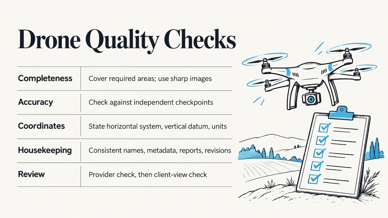
Completeness. Every required viewpoint and area is covered, no critical zone is missing, and images are sharp enough for the stated use.
Accuracy. For measured deliverables, validate against independent checkpoints rather than only the control points used to build the model. The Texas Department of Transportation’s UAS aerial mapping specification shows how seriously public agencies take this: the data provider must test and verify horizontal and vertical accuracy before delivery, and the required deliverables include flight reports, aerial triangulation and RMSE reports alongside the orthoimagery and point clouds. RMSE, or root mean square error, is the standard way to express how far measured points sit from known checkpoints.
Coordinate systems and units. State the horizontal coordinate system, the vertical datum and the units in plain language with every mapping deliverable. Construction and civil clients typically expect orthometric heights, so an unstated GPS height basis can quietly make a surface model unusable. If your client is an engineer or surveyor, this single line in the metadata saves a week of back and forth.
Housekeeping. Consistent file names, project metadata attached, a consistent report template, and a record of revisions.
Two-tier review is common in serious mapping programs. The European Union’s Copernicus emergency mapping service, for example, has the producer run its own quality check and include a quality statement, followed by a second check before delivery, and products that fall short can be revised within an agreed timeframe (Copernicus EMS quality controls). You do not need that scale, but the habit transfers: check your own work, then look at it once more as the client would.
Handling client review and acceptance
A delivery is not finished when you send it. It is finished when the client accepts it. A review process published by ONES lays out a nine-step client review and acceptance process that is worth adapting. The parts that matter most for a small provider:
- Confirm the review is against the agreed specification, not new preferences.
- Ask the client to name one coordinator for all comments.
- Give a feedback format and a deadline with the invitation.
- Tie each comment to a spec item or a location on the map.
- Sort comments into defects, clarifications, scope changes and preferences. Only defects are free fixes.
- Record formal acceptance: who, when, and which version.
Location-tied comments are where annotations earn their keep. In DataDelivery™ you can annotate imagery directly on the site data, so a note about a drainage issue or a missing area points at the exact spot instead of a paragraph of description.
Stage 6: Deliver as a link, not a folder
A useful delivery package has a clear structure, consistent names, a summary report, annotated key images and exports in the format the client works with. The delivery method matters as much as the contents. A zip of 4 GB of imagery is hard to open, easy to lose and impossible to compare with next month’s.
With DataDelivery™ you share results through a client portal under your own brand. Clients browse by map or by timeline, view orthomosaics and point clouds in the browser, and do not need to create an account. There are no per-seat fees, so adding another reviewer on the client side does not change your bill. For the step-by-step on each format, see our guides to sharing drone data with clients, sharing orthomosaics and sharing point clouds. Inspection work has its own page on delivering inspection photos, and the reports and sharing guide covers summary reports.
Managing recurring jobs and progress records
Construction firms and property managers rarely need one flight. They need the same site captured again and again, and a way to see what changed.
Three habits make recurring work pay off:
- Fix the viewpoints. Decide the cadence, priority zones and recurring angles before the first visit, and agree a weather rescheduling rule.
- Organize by visit date. Each visit gets its own dated set, with the same index of views every time, so any two dates can be compared without searching through mixed files.
- State what the record is. Imagery is a visual record. Say plainly in the scope that it documents conditions and is not a verification of schedule, payment or workmanship.
This is the structure DataDelivery™ gives you by default. You can browse by map view or by timeline, compare captures over time, and manage recurring captures from the same job. For property managers, the same archive becomes a dated visual record of each asset, and our property management page shows how that applies to inspections and monitoring. Construction teams can see how it fits a full progress program on our construction page.
Organized data also saves effort on the client side. A new contractor can open the latest site map instead of asking someone for it, and a weekly logistics meeting can start from the same current view for everyone.
Outsourcing capture and mapping work
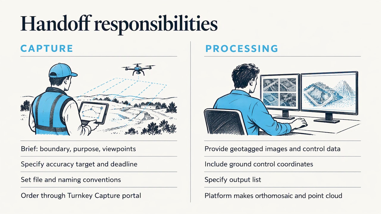
Many providers hit a point where demand outgrows their flying schedule, or where a client’s sites are spread across states. The two tasks that can be handed off are the flying and the processing. In both cases, the same discipline applies: send a clear brief, agree on the deliverables and formats, and apply your own acceptance check before anything reaches the client.
When you hand off capture, give the other party what you would want as a pilot: boundary, purpose, required viewpoints, accuracy target, deadline and the file and naming convention your delivery expects. When you hand off processing, supply the geotagged images, any ground control coordinates and the output list.
For capture, Turnkey Capture is the simplest route in our own platform: the job is ordered and completed through the online portal, and the results land in the same site-and-date structure as the rest of your work. For processing, the platform’s own orthomosaic and point cloud generation means the data does not need to leave your workflow for a separate service, which also keeps data ownership and delivery in one account.
Whatever the route, keep these three things in your own hands: the written scope, the acceptance check and the client relationship.
Match the plan to the size of your workload
DataDelivery™ plans scale with usage: jobs, processing runs and storage. Prices as published on our pricing page:
| Plan | Monthly | Yearly |
|---|---|---|
| FREE | $0 per month | n/a |
| Starter | $12.99 per month | $129 per year |
| Basic | $29.99 per month | $299.99 per year |
| Premium | $79.99 per month | $799.99 per year |
| Enterprise | $199.99 per month | $1999.99 per year |
A solo pilot with a handful of recurring clients can start at the lower tiers, while a firm running many sites and frequent processing will want the higher ones. Storage is worth planning for: see how storage and tools work before you commit large archives.
Start managing jobs in one place
If your jobs currently live across email, a desktop processing tool and a file-sharing link, DataDelivery™ brings them into one site-and-date structure with processing, annotations, reports and branded client delivery included. You can start on the FREE plan at $0 per month and move up as your job volume grows. See the DataDelivery™ plans, or explore the platform first.
If you would rather not fly the site yourself, Turnkey Capture delivers the capture and processed results through the same portal.
Our perspective
We built DataDelivery™ because the hardest part of a drone job is rarely the flight. It is everything that happens after the drone lands: finding the right files, processing them, explaining them and keeping them useful next month.
Generic file-sharing tools treat a drone dataset as a pile of files. Your clients think in properties, sites and dates, so we organize data the way they ask questions: where is it, when was it flown, and what changed since last time. Map-based browsing, time-series comparison, point cloud viewing, annotations and reports all sit on that structure.
We also believe delivery should reflect your business, not ours. Clients open results under your brand, without creating accounts, and you are not charged per seat as their team grows. Processing happens in the platform, so you do not need separate image-processing software to get from raw images to a finished deliverable.
The result we aim for is simple: better project visibility, clearer communication between you and your clients, and decisions made from data everyone can actually open.
the author
FAQ
What is the best way to keep track of multiple drone jobs?
Use one system where each job is tied to a property, site and date, and where the scope, flights, processed outputs and client comments all attach to that job. DataDelivery™ organizes jobs this way, with map and timeline browsing, so you can find any capture without searching folders.
How do I deliver drone deliverables so clients can actually use them?
Give clients a link to a branded portal rather than a zip file. They should be able to view orthomosaics, point clouds and 3D models in the browser, with a summary report and annotated key areas. With DataDelivery™, clients do not need accounts to view shared data.
Can I outsource drone mapping or capture?
Yes. Both flying and processing can be handed off if you give a written brief covering boundary, purpose, deliverables, formats, accuracy and deadline, and then check the result against your acceptance criteria. Turnkey Capture covers capture and delivers the data into the same portal as your other jobs.
What should a drone job scope include?
At minimum: site address and boundary, purpose of the data, deliverables and formats, accuracy requirement and how it is verified, deadline and weather rules, named reviewers, and who gives final acceptance. For recurring work, add the cadence and priority zones.
Sources
- TxDOT UAS Aerial Mapping Specifications and Workflow
- Quality Controls, Copernicus EMS On Demand Mapping
- How Aerial Mapping Teams Coordinate Client Review and Acceptance of Map Deliverables