The best way to share drone imagery with stakeholders is a single branded portal. It organizes every capture by property, site and date, opens in a browser, and gives you control over who sees what. Email attachments, cloud folders and one-off download links all fail the same way: files go missing, viewers can’t open them, and nobody can tell which flight is the latest. We built DataDelivery™ for this delivery step, so the people who need the data can use it without installing anything.
TL;DR
- Deliver through one link or portal per site, not through attachments or scattered folders.
- Organize by property, site and date so stakeholders can find the latest capture and compare it with earlier ones.
- Let viewers browse maps, orthomosaics, point clouds and 3D models in a browser, and add annotations and reports to explain what they see.
- Control access with permissions, and treat people and private property in imagery as a privacy issue.
- DataDelivery has a FREE plan at $0 per month, and paid plans start at $12.99 per month.
Table of Contents
- Why email and shared folders fall short
- Set up the delivery structure before you upload
- What a good aerial photo sharing portal should offer
- A repeatable delivery workflow, step by step
- Using shared imagery to track construction progress
- Handling large files and compatibility
- Sharing drone imagery securely
- Our perspective
- Start delivering from one place
- FAQ
- Sources
Why email and shared folders fall short
Drone data is heavy and spatial. A single mapping job can produce an orthomosaic (a stitched, map-accurate image of the whole site), a point cloud (millions of measured 3D points), a 3D model and hundreds of raw photos. Generic file-sharing tools treat all of that as anonymous files in a folder.
The problems show up quickly:
- Format barriers. A project manager or property owner usually has no GIS software, so a GeoTIFF or LAS file is useless to them.
- Version confusion. Files named “final_v3” in three different places leave stakeholders unsure which flight they are looking at.
- No context. A raw image can’t say “this is the area we’re worried about.” Someone has to write a separate email or mark up a PDF.
- No history. Progress tracking depends on comparing today’s capture with last month’s. A folder tree makes that a manual job.
- Weak access control. A link forwarded to the wrong person exposes a private site.
A delivery platform designed for aerial data fixes these problems at the source. That matters for all three kinds of readers: service providers who want fewer support emails, construction firms who need dependable progress records, and property managers who want organized visual documentation.
Set up the delivery structure before you upload
Most delivery trouble is an organization problem. Decide the structure once, and every later capture slots into it.
Organize by property, site and date
Use three levels:
- Property or client. The organization that owns the asset, such as a developer, a portfolio owner or a municipal department.
- Site. A specific location under that property: a building pad, a stockpile yard, a roof, a parcel.
- Capture date. Each flight is a dated entry under its site.
This mirrors how stakeholders think. They ask, “What does the north lot look like now compared with last month?” They do not ask for “the folder from the 14th.” DataDelivery organizes data by property, site and date, and lets viewers browse by map or by timeline, so the right capture is a click away.
Name deliverables consistently
If you add external products from other mapping software, keep the naming the same on every job. Include the site, the date and the product type, such as orthomosaic, point cloud or elevation model. Consistent names keep clients from opening the wrong file, and they make recurring captures easy to line up. Our guide to adding external products shows how to bring in outputs created elsewhere.
Plan recurring captures
Construction and property monitoring rely on repeat flights: weekly, biweekly or monthly. Schedule them as a series from the start. When each new capture lands in the same site record, comparison is automatic. DataDelivery supports recurring capture management, and for teams that don’t fly themselves, turnkey flight scheduling and our Turnkey Capture service handle the capture step too.
What a good aerial photo sharing portal should offer
When you evaluate how you will share imagery, check for these capabilities. They come from what stakeholders actually do with the data.
| Stakeholder need | What the portal should provide |
|---|---|
| See where things are | Map-based browsing with orthomosaics overlaid on a basemap |
| Find the right date | Timeline browsing and side-by-side comparison of captures |
| Understand terrain and structures | 3D model and point cloud viewing in the browser |
| Quantify work | Stockpile volume and contour measurement tools |
| Point at an issue | Annotations placed directly on the imagery |
| Keep a record | Reports that can be generated and shared |
| Stay simple for the viewer | No software install, no required client account |
DataDelivery covers each row. Our Map View guide and guide to viewing deliverables walk through how a viewer moves around a site. Orthomosaic and point cloud generation happen inside the platform, so you don’t need separate image processing software before you deliver.
A repeatable delivery workflow, step by step
Step 1: Upload and process the capture
Upload raw images or finished products to the site record. The usual failure here is a stalled upload or a processing step done in a separate program that then needs a second upload. In DataDelivery, processing into orthomosaics, point clouds and 3D models happens in the same platform, so you upload once.
Step 2: Check the output before the client sees it
Open the result in the viewer and confirm it covers the site, lines up with the previous capture and has no obvious stitching errors. Catching a gap now is cheaper than a client finding it. You are looking at the same view your stakeholder will see.
Step 3: Add context with annotations and measurements
A map with no explanation makes people guess. Mark the areas that matter, such as a drainage problem, a completed slab or a roof section with damage, and attach short notes. Use the stockpile and contour tools when the question is quantity. Our annotation guide covers the details.
Step 4: Build the report
Some stakeholders want a summary, not a viewer. Generate a report from the capture, with annotations and key views, and share it alongside the live data. The Reports & Sharing guide explains the options, and our client portals and reports page shows what the recipient sees.
Step 5: Share under your brand
Send the portal link. The viewer opens it in a browser, under your branding, without making an account. We don’t charge per seat, so adding a project manager, an owner and a lender costs nothing extra. That makes it easy to include everyone who needs the data, rather than rationing access to control cost.
Step 6: Confirm and keep the record
Ask the client to confirm they can open and use the data. Then leave it in place. Because every capture stays under its site and date, the archive builds itself, and the link still works when someone asks about the site a year from now.
For a longer walk-through of the delivery routine, see our guide on how to share drone data with clients. If your main deliverable is a map, sharing orthomosaics with clients goes deeper. For 3D data, see sharing point clouds with clients.
Using shared imagery to track construction progress
Construction teams get the most value from time comparison. A weekly or monthly capture of the same site, viewed side by side, shows what changed without anyone standing in the mud.
A practical routine:
- Fix the capture schedule to match the project’s milestones: site prep, foundations, framing, envelope, finishes.
- Fly the same area each time so overlays line up.
- Compare captures in the viewer by switching dates on the same map.
- Annotate the differences that matter to the owner, the general contractor or the lender: completed areas, delayed areas, stockpile changes.
- Send one report per period that links back to the live data.
Owners and lenders see progress in context, and superintendents spend less time writing updates. Property managers use the same pattern for roofs, parking lots and grounds. A dated record of condition is useful documentation when questions come up later. Our property management page describes that use, and our inspection photo delivery page covers photo-based inspections.
Handling large files and compatibility
Orthomosaics and point clouds can be very large, and the person receiving them rarely has a fast connection or specialist software. Two principles help.
First, send a link to a viewer, not the file. The recipient browses the data online and downloads only if they need to. If you also need to hand over bulky raw files, such as full-resolution archives for an engineering team, use reliable, access-controlled file sharing rather than email attachments, so the transfer is traceable and you can end access when the project closes.
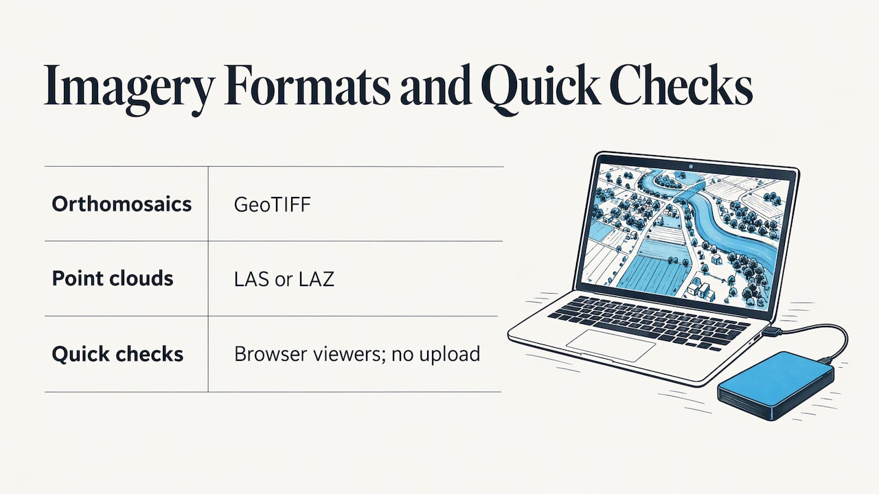
Second, keep formats open. When a stakeholder does have GIS tools, they will want standard outputs such as GeoTIFF for maps and LAS or LAZ for point clouds. If you only want to check a file quickly, our GeoTIFF viewer and LAS and LAZ viewer open files in the browser without uploading them. Mac users can see their options on our drone mapping software for Mac page.
Sharing drone imagery securely
Secure sharing means two things: controlling who can open the data, and handling what the images show.
Control access
The approach used by large organizations is a good model. The US Department of the Interior’s Imagery Data Management platform keeps designated data private in a secure location and uses a permissions-based sharing model. Bureaus choose whether data is open to the public, limited to their organization, or shared with other bureaus. Apply the same logic to a client project:
- Give each site its own link or portal, so sharing one project never exposes another.
- Share only the sites and dates a stakeholder needs.
- Review who has access when a project ends or a contract changes.
- Keep private sites out of public channels such as social media.
Handle people and private property in the imagery
Aerial images can capture faces, vehicles, backyards and neighboring properties. Rules differ by country. In the US, they depend on state law and the site, so check with your attorney if a project involves private residences or public spaces.
For readers who work in Europe or share data with European clients, the picture is firmer. EASA’s Code of Conduct on drone privacy says that sharing personal data with clients or processors should be formalized in a GDPR-compliant agreement covering purpose, data categories, retention, security and sanctions. Transfers outside the EU and EEA need a legal safeguard, such as an adequacy decision or standard data protection clauses. Spain’s data protection authority, in its drones and data protection guide, recommends minimizing identifiable people in captures, reducing resolution and geolocation detail to what is necessary, and encrypting data. It also advises removing unnecessary personal data as soon as possible, and carrying out a data protection impact assessment where required.
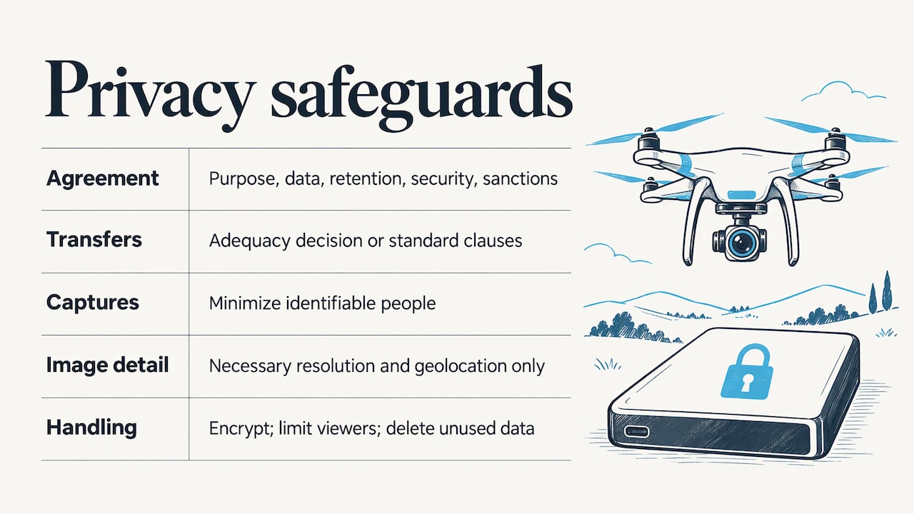
In practice, capture only what the job needs, limit who can view it, and delete what no longer serves a purpose.
Our perspective
Drone work has four stages: plan, fly, process and deliver. Most operators put their effort into the first three and improvise the last. The result is a good survey handed over in a way that makes the client’s life harder.
We built DataDelivery around the idea that the deliverable is not a file. It is an organized, browsable record of a site over time. That is why we structure everything by property, site and date, why viewers can move between a map, a timeline, a point cloud and a 3D model, and why annotations and reports sit next to the imagery they describe.
We also think delivery should not penalize you for including people. There are no per-seat fees, and clients don’t need accounts to view what you share. Your brand is what they see. The data is processed in the same place it is delivered, so there is no separate image processing tool to buy and learn.
Construction firms get progress tracking they can trust, property managers get documentation that stays organized, and service providers get a delivery experience that makes clients want to book the next flight.
the author
Start delivering from one place
DataDelivery has a FREE plan at $0 per month, so you can set up a site and try the structure on a real project. Paid plans scale with jobs, processing runs and storage:
| Plan | Monthly | Yearly |
|---|---|---|
| Starter | $12.99 | $129 |
| Basic | $29.99 | $299.99 |
| Premium | $79.99 | $799.99 |
| Enterprise | $199.99 | $1,999.99 |
See the details on the pricing page, or look at the DataDelivery platform first. If you need the flights flown as well as delivered, our Turnkey Capture service covers capture and processing through the online portal.
FAQ
What is the easiest way to share drone imagery with stakeholders?
Send one link to a browser-based portal where the stakeholder can view the map, 3D model or point cloud without installing software. Organize the data by site and date so they can find the latest capture. With DataDelivery, viewers don’t need an account.
How do I keep shared drone imagery secure?
Share per site, limit access to the people who need it, and remove access when the project ends. Large organizations such as the US Department of the Interior use permissions-based sharing for this reason. Also minimize identifiable people and private details in the images you capture and share.
Can clients compare drone captures over time?
Yes, if each flight is stored under the same site with its date. DataDelivery offers timeline browsing and time-series comparison, so a client can switch between dates on the same map and see what changed.
What should a construction photo sharing platform include?
Look for map-based browsing, date comparison, annotations, measurement tools and reports. These let owners, contractors and lenders see progress and discuss specific areas without a site visit. DataDelivery includes all of them, along with stockpile and contour measurements.
Sources
- Imagery Data Management, US Department of the Interior
- Code of Conduct, EASA
- Drones and Data Protection, AEPD